|
|
| Home
| Price List
| Contact Us
|
 |
Urban Geography
(ISSN 0272-3638)
|
IMPORTANT ANNOUNCEMENT
Urban Geography is now published by Taylor & Francis Group.
To be directed to the new journal homepage at Taylor and Francis, to place an order or if you have any queries please use the following contact details and link.
Urban Geography, www.tandfonline.com/rurb, (ISSN 0272-3638)
Subscription Information
For subscription information, please contact Taylor & Francis at:
Web: www.tandfonline.com
E-mail: subscriptions@tandf.co.uk
United Kingdom
All other customers: +44 (0)207 017 7720
For agents: +44 (0)207 017 7529
United States
+215 625 8900 or +1 800 354 1420
Singapore
+65 6508 2862
Australia
+61 3 8842 2413
Cover Photos
2012
| 2011
| 2010
| 2009
| 2008
| 2007
| 2006
| 2005
| 2004
| 2003
| 2002
2012
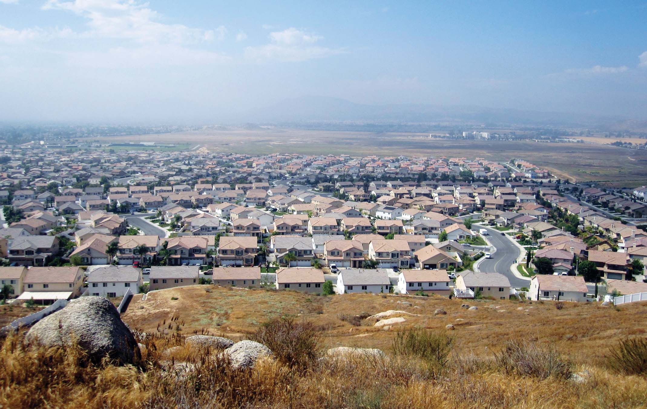
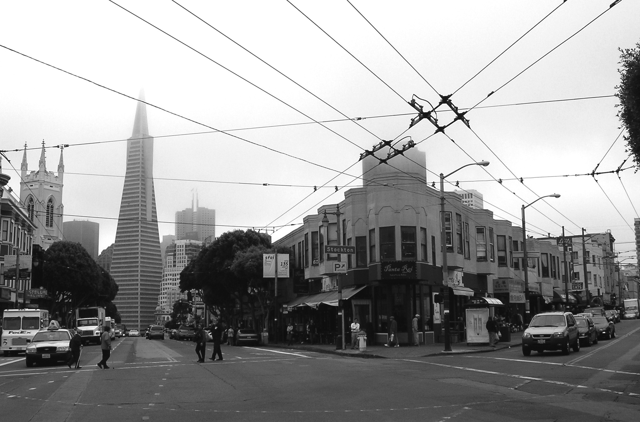
Volume 33, Issue 1: Exurban Housing Development in Moreno Valley, California.
Photograph courtesy of Dierdre Pfeiffer.
A late afternoon vista of Moreno Valley, California, a fast-growing, racially diverse Los Angeles exurb that has come of age in the post–Civil Rights era. African Americans seeking “more housing for less” and an escape from the persistent gang violence and rapid Latinization of South Los Angeles have been contributing to its growth since the early 1980s, earning it acclaim as a “Little Compton.” Built in part on the back of risky lending, it also is one of the epicenters of the recent foreclosure crisis. Immediately out of frame are the largely vacant Pacific Iris and Eagle subdivisions built by Pacific Communities, with signs offering prospective home buyers “4 to 7 Bedrooms,” “Up to 4,568 Sq. Ft.,” and “Golf Course Living.”
— Dierdre Pfeiffer, Arizona State University
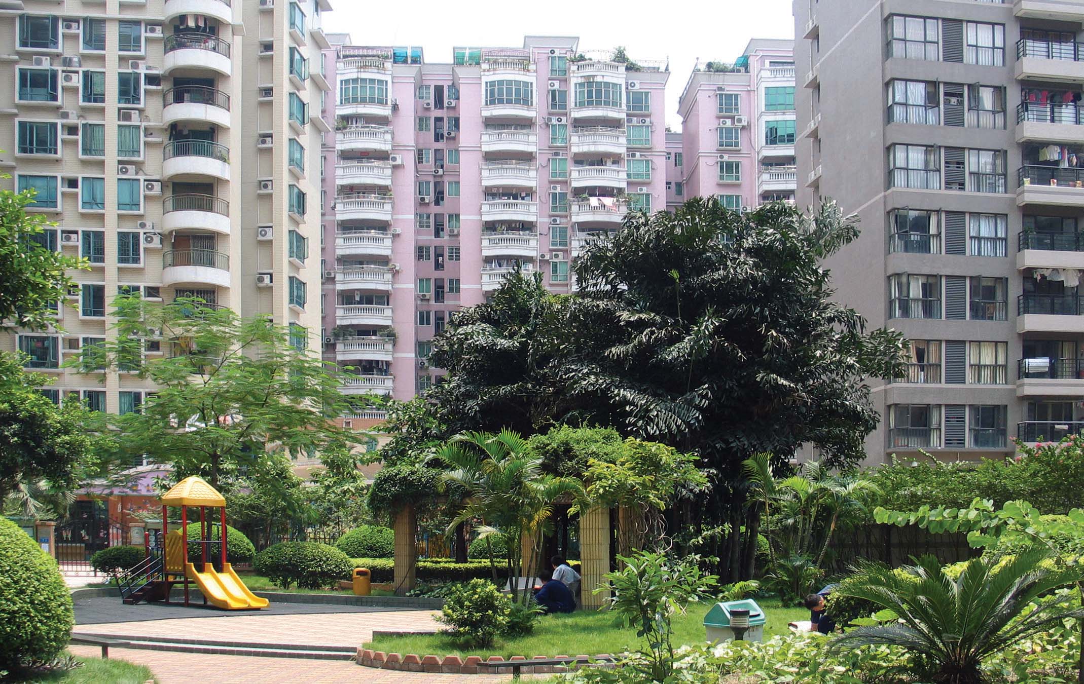
Volume 33, Issue 2: Interior of Mayfair Garden (Meihaoju), a gated community in Guangzhou, China.
Photograph courtesy of Yushu Zhu.
This image, taken in Guangzhou in 2008, features a commodity housing estate (xiaoqu) in urban China, which has become the dominant neighborhood form in Chinese cities since the late 1990s. These new developments bear physical characteristics and social composition distinct from those of the traditional closely knit neighborhoods developed in the socialist era. Most commodity housing estates are gated communities, comprising multi-story apartment blocks together with such amenities as landscaped gardens, playgrounds, recreation centers, etc. They cater primarily to the nouveau riche and the new middle class of professional and managerial workers.
—Si-ming Li, Hong Kong Baptist University

Volume 33, Issue 3: Urban farm at a food bank in a Detroit neighborhood.
Photograph courtesy of Kathryn Colasanti.
This image, taken in July 2009, shows a portion of the Earthworks Urban Farm in Detroit, Michigan, including both seasonal beds and a passive solar greenhouse (also known as a hoop house). The 1.5-acre farm is a program of the nearby Capuchin Soup Kitchen and the majority of its produce is incorporated into meals at the soup kitchen. The farm also hosts garden education classes and youth programs for area kids. As evidenced by the streetlights and house in the background, the farm is located in a residential neighborhood and sits just over two miles from the heart of Detroit’s downtown.
—Kathryn J. A. Colasanti, Michigan State University

Volume 33, Issue 4: “Music From Tomorrow’s World”: Album cover design for Sun Ra by Claude Dangerfield, 1960.
Reproduced with permission of Adam Abraham and Special Collections Research Center, University of Chicago Library.
This illustration was created by Claude Dangerfield in 1960 as a possible album cover for the musician and composer Sun Ra but was never used by him. Dangerfield was a Chicago-based illustrator who attended DuSable High School with Alton Abraham, Ra’s business manager, and who did a number of cover designs in the 1950s for Sun Ra Arkestra albums that were not released by the group’s record company, El Saturn, until the following decade. Ra’s music of this period, like the illustration reproduced here, was strongly interested in utopian cities as well as, more generally, the ability of musical space to create other worlds.
—William Sites, University of Chicago

Volume 33, Issue 5: Site of the segregation-era black-owned Hicks Restaurant and Market, Arlington County, Virginia, 1960.
Reproduced with permission of the Virginia Room, Arlington Public Library.
During segregation, the Hicks famliy made life more comfortable for residents of historically black Halls Hill in Arlington, Virginia. While blacks were limited to ordering takeout food from the back door of white-owned restaurants, they could enter the front door of the Hicks Restaurant, sit down, and eat their meal in peace. The Hicks Market sold groceries "on account," payable on pay day. The outdoor Hicks Beer Garden took the edge off sultry Virginia summer evenings. The Hicks Bus Line connected Halls Hill with work, shopping, and school opportunities across the Potomac River in Washington, DC. Once the constraints of segregation were lifted, Halls Hill residents explored previously forbidden dining and shopping options. The guaranteed customer base that supported the Hicks enterprise evaporated. The Hicks family went out of business and the building fell in disrepair, as seen on this image taken in 1960. Eventually the buliding was demolished and replaced with a fast food restaurant.
—Nancy Perry
George Mason University

Volume 33, Issue 6: Morning market, Semarang, Indonesia, 2007.
Photograph courtesy of Donovan Storey.
This image, taken of one of Semarang's most popular early morning food markets, reflects the vibrancy and energy of urban centers, but also captures in one small part the challenges faced in managing urban space. Though appearing permanent, the market rapidly closes mid-morning, giving way to clothing and small-item traders, providing an opportunity for others to make their livelihood. In its immediate aftermath the market leave an incredible amount of waste which is evidently disposed of in very haphazard ways. However, its significance for both rural and urban citizens - not only in terms of food security and income, but also in the creation of communities - cannot be denied.
—Donovan Storey
University of Queensland
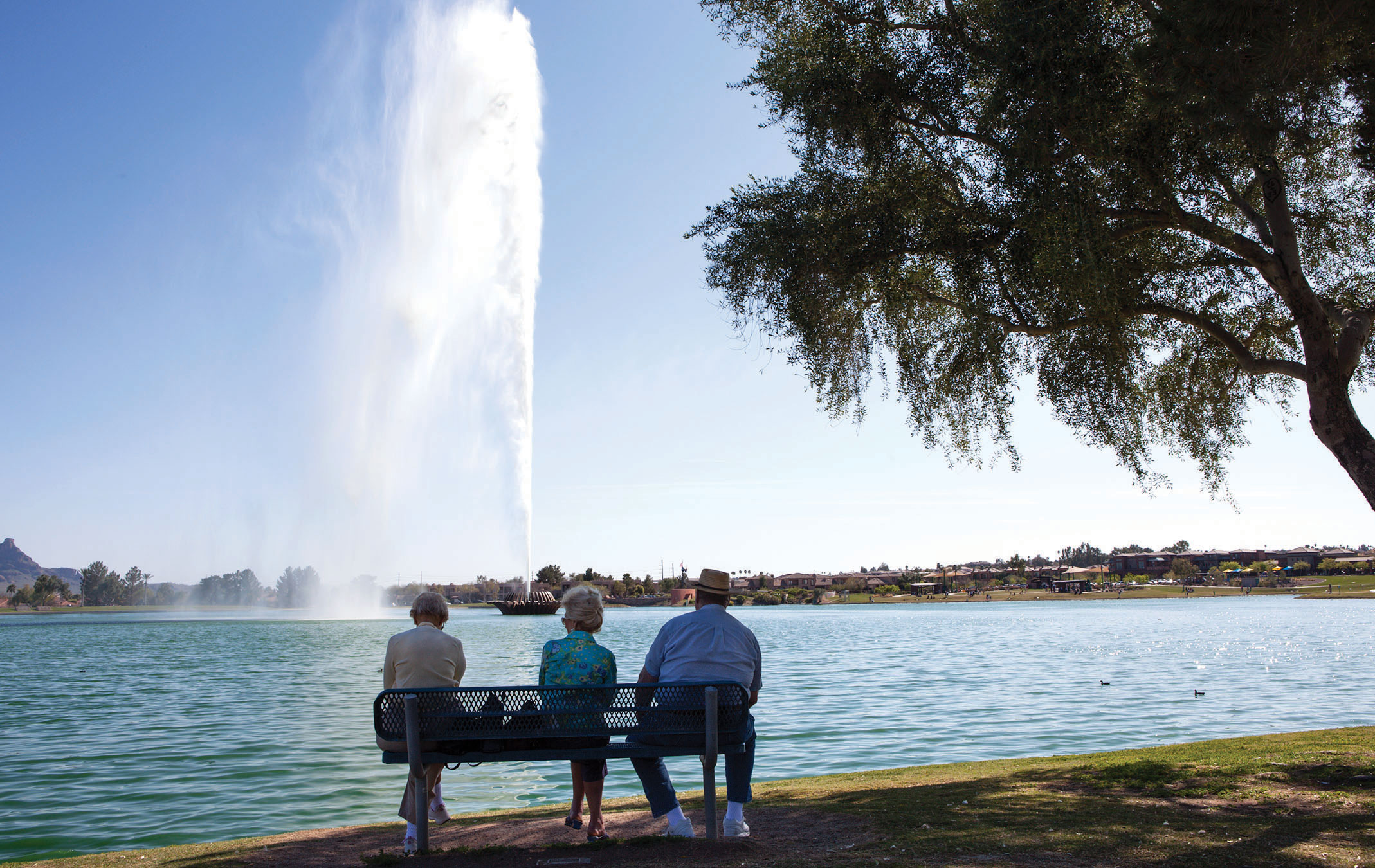
Volume 33, Issue 7: Retirees take in the soaring fountain of Fountain Hills, adjacent to Phoenix, Arizona.
Photo courtesy of Edgar Cardenas.
Desert dwellers have long used water as means of survival and source of comfort against scorching summer heat. This photo shows the world's fourth tallest fountain in the desert metropolis of Phoenix, Arizona. The fountain sprays water for about 15 minutes every hour between 9 a.m. and 9 p.m. and is the signature feature of the Town of Fountain Hills, developed by Robert P. McCulloch in the early 1970s. Today the lake is filled with reclaimed effluent and is a point of pride for local residents who gather in the surrounding park to watch the plume and for respite from the heat. The drive for urban water conservation, while a laudatory goal, risks the loss of the cooling and soothing effects of water in the desert.
—Patricia Gober
Arizona State University
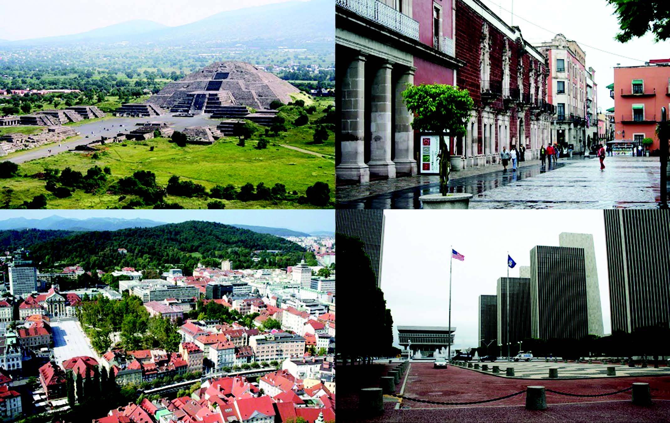
Volume 33, Number 8: Urban Plazas in Comparative Historical Perspective.
Photo courtesy of Benjamin W. Stanley
The four cover images compare urban plazas from different historical, geographical, and cultural contexts: the Plaza of the Moon in pre-Columbian Teotihuacan, Mexico (top left); Congress Park, a 19th century European, mixed green/grey space in Ljubljana, Slovenia (bottom lef
t); the 17th-century, Spanish colonial Plaza de la Patria, Aguascalientes, Mexico (top right); and the 20th-century modernist Governor Nelson A. Rockefeller Empire State Plaza, Albany, New York, USA (bottom right). When classifying urban open spaces across human history, all four places would be considered plazas at the city-wide scale, perhaps the most widely recognized category and scale of urban open space. Each space was planned by government authorities and projects the symbolic power of top-down government control, a goal especially apparent in Teotihuacan and Albany. At the same time, each has been appropriated by grassroots initiatives for social, political, and other purposes; for example, the plazas in both Ljubljana and Aguascalientes have been sites of political assembly and contestation in history, and now serve as important sites for social interaction, leisure, and tourism.
—Benjamin W. Stanley
Arizona State University
Back to the Top
2011

Volume 32, Issue 1: Birmingham Eastside, a former manufacturing area that may be transforming into a creative quarter.
Photograph courtesy of Marco Bontje, University of Amsterdam
Eastside is the focus area of Birmingham's current urban regeneration program. The former manufacturing and working-class area has meanwhile attracted a growing number of creative companies. Eastside is emerging as a center of multimedia
activities, graphic design, visual arts, and music production and performance. As in many other European cities, creative industries
are seen as a possible driving force behind urban regeneration in Birmingham. However, Birmingham's former specialization as a
manufacturing city now is a disadvantage in the international competition with cities with a richer tradition in cultural and serviceoriented activities such as Amsterdam or London. Next to attractively redeveloped former factories, Eastside still also features many derelict buildings and vacant lots, the redevelopment of which may prove difficult if not impossible. —Marco Bontje, University of Amsterdam 
Volume 32, Issue 2: Drumming and dancing during the Calle Ocho Festival, Little Havana neighborhood of Miami, Florida, 2006.
Photograph courtesy of Patricia Price, Florida International University
Miami's famed Calle Ocho, also known as Southwest Eighth Street, runs through the heart of Little Havana. The
commercial landscape lining this thoroughfare reflects both the longstanding Cuban exile businesses and, more recently, commerce
owned by and oriented toward a multinational Latino population. Calle Ocho is also home to what has been called "the world's biggest
block party." The Calle Ocho Festival is the climax of the Carnival Miami events held each year during the Lent season. Although
the Kiwanis Club of Little Havana, which hosts the event, is a primarily Cuban-led organization, the festival is pan-Latino in spirit.
Over one million people from across the United States and internationally reportedly attend the festival, packing into just over twenty
blocks of Calle Ocho that have been closed to vehicle traffic for the event. Revelers enjoy food and purchase souvenirs from across
the Americas. Without a doubt, the main attraction of the Festival is the many musical performances, both scheduled and spontaneous.
The cover image is an example of the latter. —Patricia Price, Florida International University 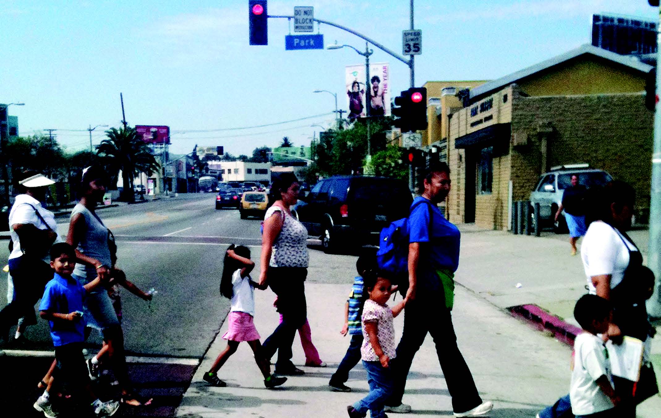
Volume 32, Issue 3: Crossing Sunset Boulevard at Park Avenue in the Echo Park neighborhood of Los Angeles, October 2010.
Photo courtesy of Jessica Meaney, Safe Routes to School National Partnership.
Echo Park, an older urban community just north of downtown Los Angeles, represents a vision of safe streets for
people from all walks of life. It was the center of the movie industry in the early 20th century before Hollywood was developed, and
in the mid-20th century developed sizable Cuban and Filipino communities. It is undergoing moderate commercial gentrification and
is a rare example of a neighborhood undergoing a degree of Hispanic-to-white transition: between 2000 and 2010 its core census tract,
1974.20, went from 70% to 60% Hispanic and from 13% to 23% white, with the balance predominantly Asian. —Michael Reibel, California State Polytechnic University, Pomona 
Volume 32, Issue 4: Municipal Incorporation in the USA.
Image courtesy of Russell M. Smith, Winston-Salem State University and Tyra Keene, Graphic Designer.
Collage of city/town limit signs of Newly Incorporated Municipalities (NIMs) located within the Piedmont Triad of
North Carolina. The collage seeks to depict the continuing urban fragmentation that besets the United States through the proliferation
of NIMs across the country. —Russell M. Smith, Winston-Salem State University 
Volume 32, Issue 5: Corner store offering limited healthy food options for low-income
WIC and SNAP customers, Philadelphia, PA.
Photo courtesy of Ashley Ortiz, Witnesses to Hunger Program, Drexel University.
Many low-income parents do not have access to healthy food stores or fresh food products, and thus resort to mini-marts and corner stores, such as the one depicted in the photo. Here they often encounter aisles of liquidation merchandise covered in dust, and can expect to purchase high-priced, second-rate food products with WIC checks and food stamps.
—Ashley Ortiz, Drexel University

Volume 32, Issue 6: Street Celebration Following Team Canada’s Hockey Gold Medal Victory
in the 2010 Winter Olympics, Vancouver
Photograph courtesy of John Goldsmith, freelance photographer (www.johngoldsmithphotography.com)
In an instant, a massive street party ensued following the Gold Medal hockey game of the 2010 Winter Olympics in Vancouver, Canada (won by Team Canada). From my vantage point at the epicenter of Granville and Robson, the crowd’s energy was seemingly unstable even if people’s movements were only incremental. Thankfully, this was a celebration and everyone’s spirits were high. Vancouver’s now infamous 2011 hockey riot occurred scarcely more than a year later, when the home team Canucks lost the deciding Game 7 of the Stanley Cup Final. In retrospect, the Olympic crowd probably could have gone either way. And, now, given more recent events, there was more than one reason to be thankful that the home team won.
—John Goldsmith

Volume 32, Issue 7: Homeless man cooking evening meal in a St. Petersburg staircase.
Photograph courtesy of Tova Höjdestrand, Lund University.
Tolik and his two companions stayed in this St. Petersburg stairway for about six months in 1999, conveniently close to the markets and railway stations where they eked out a livelihood from scavenging and various informal odd-jobs. He never talked about his past, but according to the others it included a failed attempt to run a business and debts to a criminal gang. He escaped his creditors only a few years earlier, while his co-habs lost their homes already in the Brezhnev era and then spent most of their lives in prison until 1991, when homelessness was decriminalized and they ceased to be invisible. Their campfire was unusual—few residents tolerate such fire hazards—but otherwise most homeless people I met during my research survived in a similar manner. The state provided no social support, but instead people survived thanks to a dilapidated housing stock and a ubiquitous shadow economy. This was a temporary respite, however; only a few years later, money started to roll again. The city eliminated homeless hangouts by massive refurbishments, while residents barred their apartment blocs with proper electronic door locks. In the end, people such as Tolik and his co-habs had access neither to odd-jobs nor sleeping places, and could no longer be seen in the central city. Somewhat paradoxically, they now became as invisible as during the Soviet era—but due to neoliberal city planning instead of criminalization.
—Tova Höjdestrand,
Lund University
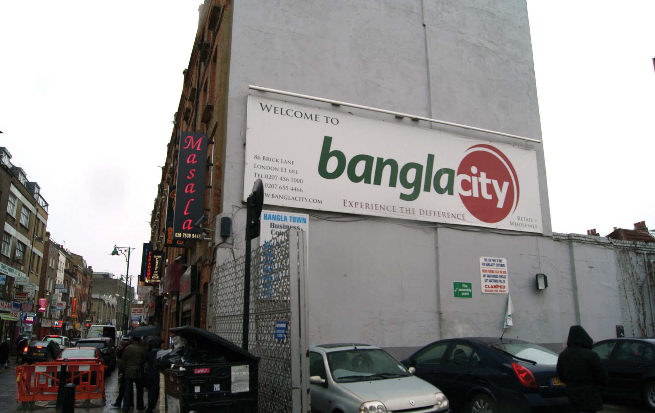
Volume 32, Issue 8: “Bangla Town”: Brick Lane, East End of London, 2010
Photograph courtesy of Geoffrey DeVerteuil
This image, taken in February 2010 along Brick Lane, East End of London, clearly conveys the intensely Bangladeshi flavor of the street, both in terms of restaurants but also less visibly of mosques, nonprofit services, and cultural infrastructure. Long a site of immigrant community (Hugenots, then Jews), Bangladeshi seamen began arriving in the 1960s. By the 1980s, Brick Lane was the symbolic heart of the Bangladeshi community UK-wide. Only a stone’s throw from the financial core, Brick Lane has experienced increasing commercial gentrification since the 2000s, becoming a mixed commodified site of ethnicity—as the image plainly shows—and, on its northern edges, more traditionally upgrading.
—Geoffrey DeVerteuil, University of Southampton
Back to the Top
2010

Volume 31, Issue 1: Arrested development in an urban landscape: Might Lodz Poland portend the future?
Photograph courtesy of Lawrence A. Brown, Ohio State University
In a recent visit to Lodz (pronounced, more or less, as "Woodge") Poland I was struck by the urban landscape as,
seemingly, locked in a time warp, not unlike my hometown of Erie Pennsylvania, an American Manufacturing Belt gemstone that is
now mired in post-Fordist malaise. As represented in the cover photo, Lodz's center is marked by empty lots (foreground), turn-ofthe-
century architecture (center mid-ground), functional block-style buildings (right foreground), and a Socialist Realism tower (right
mid-ground). The latter was built as a telecommunications center, opened in 1956, and today houses TVP Lodz, member station of
the Polish public broadcasting network. The TVP Lodz building is strikingly similar in appearance to Warsaw's Palace of Culture
and Science, opened in 1955, originally prefaced by "Joseph Stalin," and a common landmark colloquially known as PKiN. Both
buildings continue to dominate their respective skylines, twenty years after dissolution of the Iron Curtain, even though Warsaw is
the largest Polish urban area and Lodz second (essentially identical in size to Krakow). What, then, does Lodz's downtown landscape
suggest about Eastern Europe's urban evolution more generally; what might we glean from its layers of architectural styles that refl ect bygone eras but neither present styles nor those of the past half-century? — Lawrence A. Brown, Ohio State University 
Volume 31, Issue 2: Slum settlements in Kiberia area, Nairobi, Kenya
Photograph courtesy of Charles Ndegwa Mundia
Slum settlements in Kibera area within the Nairobi city. As many as 250,000 people are squeezed into the slum's six
square miles on the outskirts of Nairobi, living in makeshift houses of mud, wood and tin. These slum settlements have no access
to services such as water, sewage, and solid waste disposal, which poses serious public health problems to the residents. Lack of a
clear policy that would facilitate and guide urban development and the steady drift of people from rural areas to the city in search of
unavailable jobs continues to exacerbate the problem. — Charles Ndegwa Mundia 
Volume 31, Issue 3: Cyber Towers: Visioning high-tech Hyderabad
Photograph courtesy of Diganta Das, National University of Singapore
As Chief Minister of Andhra Pradesh (AP), N. Chandrababu Naidu oversaw the development of an IT park known
as the Hyderabad Information Technology Engineering Consultancy (HITECH) city from 1997. The ten storey intelligent building,
Cyber Towers, is the symbolic centerpiece of this IT park which was later expanded and renamed Cyberabad (in 2001). Inspiration for
this development came from Malaysia's Multimedia Super Corridor (MSC) and, in particular, the 'intelligent city' Cyberjaya which
was built to attract and house high-tech companies – and which Naidu visited. High-tech urban emulation from Malaysia to Andhra
Pradesh also involved the consultants McKinsey and Company who were involved in both MSC and so-called 'AP Vision 2020' plans
in which the idea of creating a 'knowledge corridor' such as Cyberabad features prominently. — Tim Bunnell, National University of Singapore 
Volume 31, Issue 4: High-density residential redevelopment in the core area of Toronto
Photograph courtesy of Pierre Filion, University of Waterloo
The core area of Toronto has experienced high-density residential redevelopment at a scale that is unique in North America. From 1981 to 2006, the population residing in census tracts located within 2 km of the peak-land-value intersection has
increased from 82,161 to 130,212, and residential development is ongoing at a rapid pace. Most of the growth has taken place in
high-rise condominium buildings. There are advantages to this form of development. It reduces transportation demand, and especially
reliance on the automobile. The most popular mode of transportation for people living in the core is walking, followed by
public transit and, lastly, driving. If the news is good from an environmental perspective, there are social downsides to the Toronto
core redevelopment experience. The size and cost of recent core area housing is transforming the district into a ghetto for well-to-do
childless households. — Pierre Filion, University of Waterloo 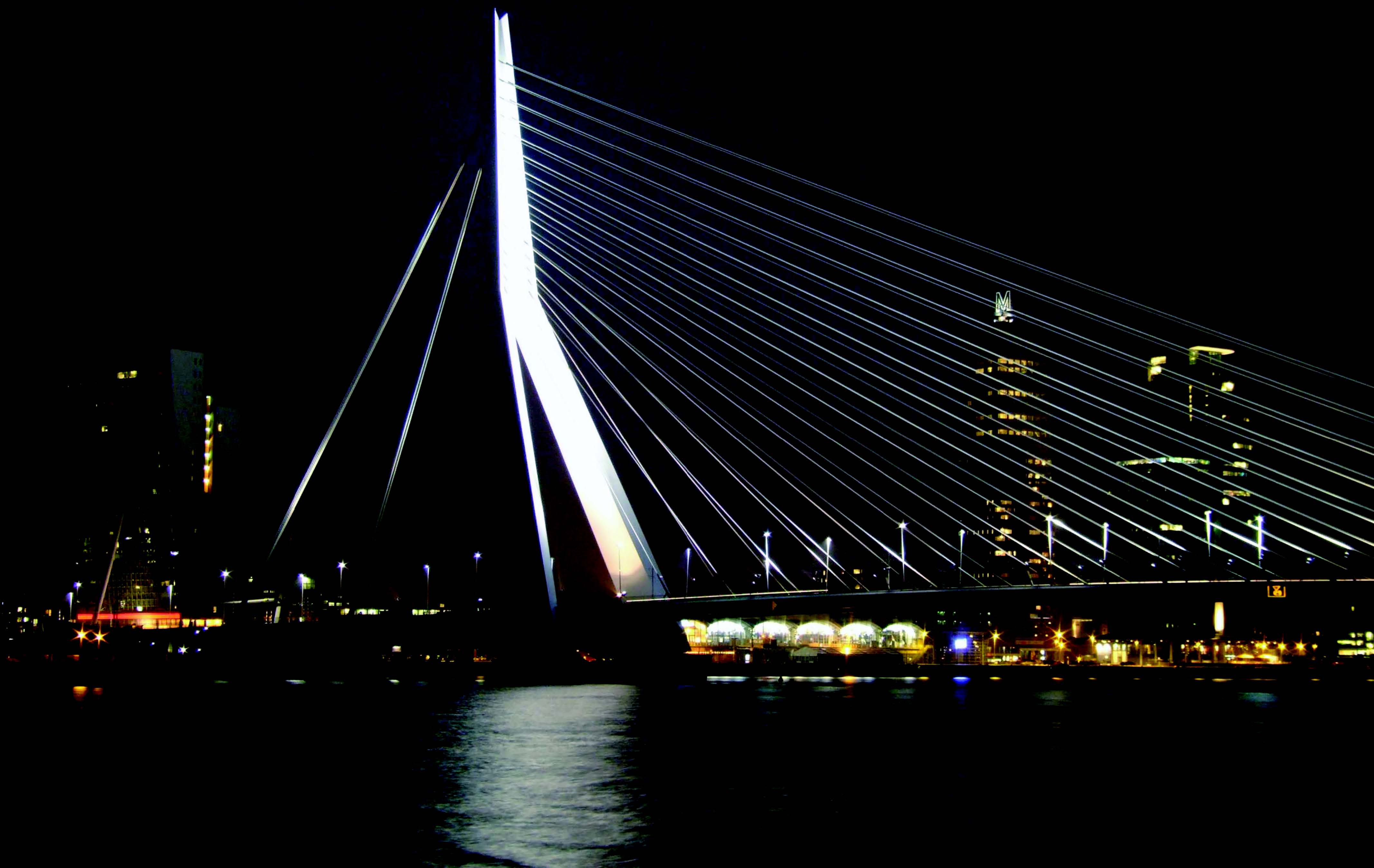
Volume 31, Issue 5: Erasmus Bridge, Rotterdam, The Netherlands
Photograph courtesy of Antonio P. Russo, University Rovira i Virgili
The Erasmus Bridge in Rotterdam, designed by Ben van Berkel, was completed in 1996. Connecting the north and
south banks of the River Maas, the bridge is 802 meters long, 139 meters high, and weighs 6,800 tons. It has become both a physical
as well as symbolic link between the city center and the Kop van Zuid, an important and successful redevelopment project that shifted
part of the social-economic weight from the CBD to an impoverished part of the city after it was abandoned by the port activities formerly located there. The Erasmus Bridge has raised the accessibility of the Kop van Zuid enormously and has attracted many creative
industries and skilled workers as well as significant inward investments to the area. — Jan van der Borg, Ca' Foscari University of Venice 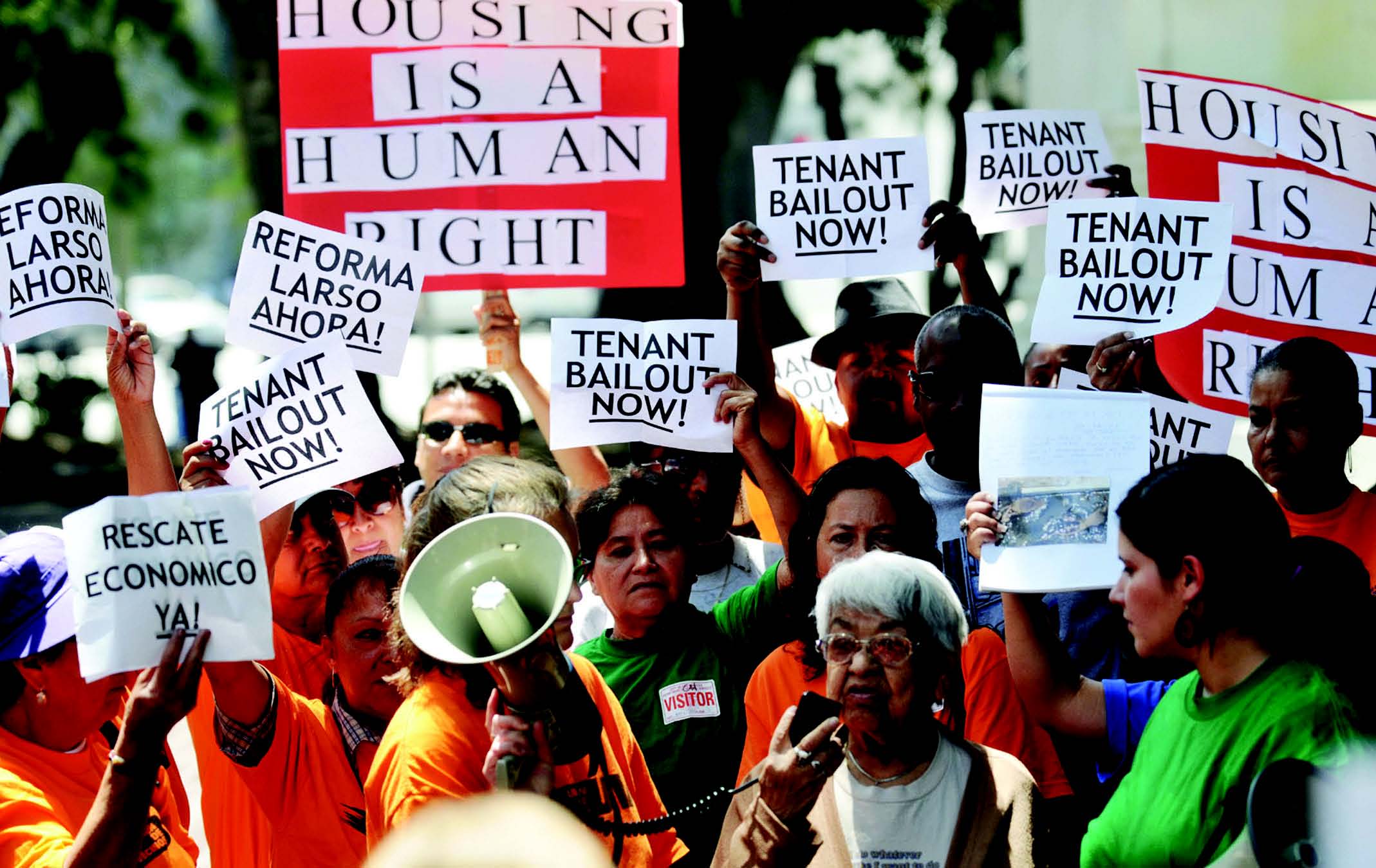
Volume 31, Issue 6: Low-income tenants from across Los Angeles region fight for rent increase freeze
Photograph courtesy of Nicholas Dahmann, University of Southern California
The Los Angeles Right to Housing Collective (LARHC) began in late 2009 following the visit of the UN Rapporteur
on adequate shelter. An outgrowth of ongoing organizing by community groups in different parts of Los Angeles, the LARHC is
composed of spatially separated multi-racial communities facing extreme rent burdens and homelessness. While the LARHC consists
primarily of low-income tenants, housing advocates and lawyers are centrally involved. In this way, the LARHC has become
a networked articulating point for distinct communities in the contest of their displacement and dispossession. These diverse but
structurally related issues work to focus the spatially dispersed Los Angeles built and social landscape. Moreover, such grassroots
organizing work represents the ongoing renegotiation of multi-scalar struggles as they materially impact the daily lives of individuals
and communities. Together, these efforts represent one cutting edge in contemporary social movements seeking to enact basic human
rights in the face of wide and widening inequality and overt governmental hostility to democratic claims. — Nicholas Dahmann, University of Southern California 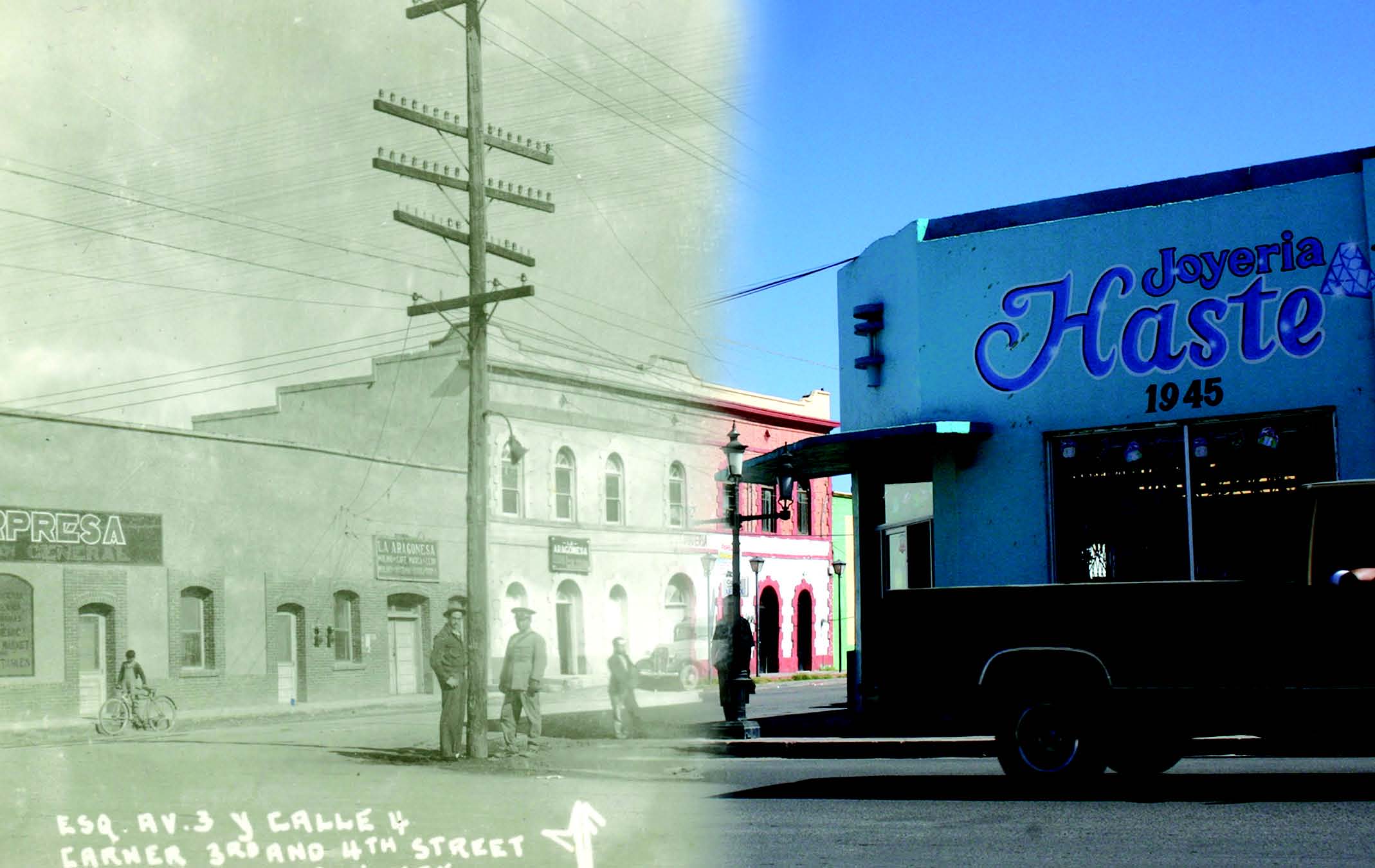
Volume 31, Issue 7: Repeat photographic mash-up of street corner in Agua Prieta, Sonora, Mexico
Image courtesy of Nick Burkhart, University of California, Los Angeles
This repeat photographic mash-up, showing the intersection of Avenida Panamericana and Calle 4 in Agua Prieta,
Mexico is a composite image consisting of a historic postcard photograph, created in approximately 1940 by México Fotografico, and
a contemporary view created by Nick Burkhart in 2008. The intersection pictured lies in the heart of Agua Prieta's commercial centro,
several blocks south of the U.S.-Mexico border. Historic postcard imagery provides researchers with snapshots of a place's vernacular
landscape, often offering details that may be absent from other forms of historical data. As this composite photograph suggests, it is
also possible to organize multiple photographs of an urban place into a series of views, which provide unique visual insights into the
evolution of an urban landscape. — Nick Burkhart, University of California, Los Angeles 
Volume 31, Issue 8: Municipal service delivery core in central Ghent, Belgium.
Photograph courtesy of Tijs Neutens, Ghent University
The Woodrow Wilson square, named after the 28th president of the United States, in central Ghent, Belgium gathers
various municipal services regarding civil affairs, land use planning, mobility and the public domain. The local authorities of Ghent
are currently exploring the opportunities to improve citizens' access to urban service delivery. In particular, they are (re)investigating the equitability of the spatial distribution and the operating hours of government offices in the city. The aim of these efforts is to discover blind spots and overserviced areas and to better attune the operating hours of service delivery to the mobility and time use patterns of the citizens. — Tijs Neutens, Ghent University Back to the Top
2009
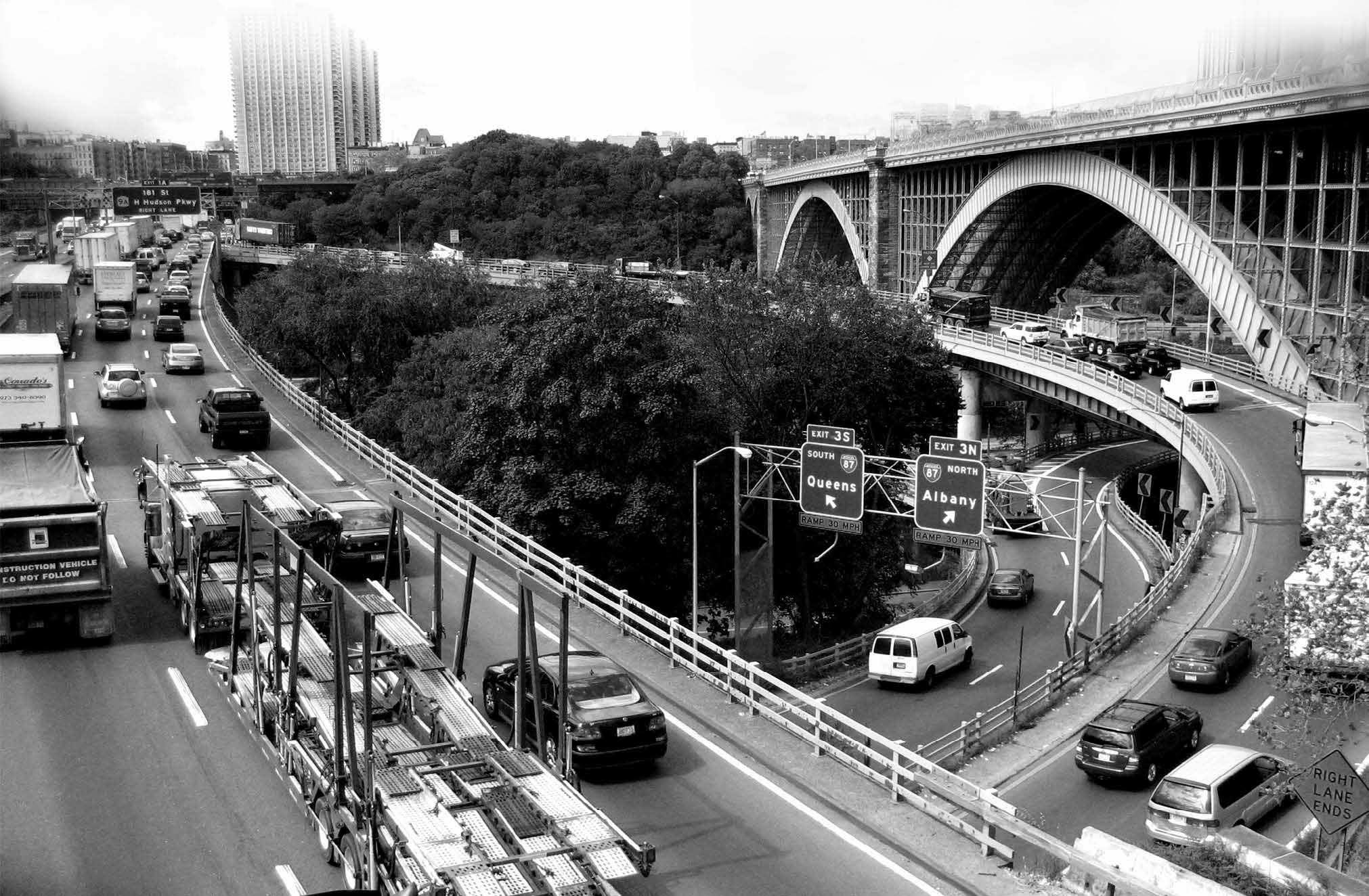
Volume 30, Issue 1: "Highways of the Bronx - Yesterday's "City of Tomorrow," Today"
Photo courtesy of Brian Morgan, City University of New York, Lehman College
This image is a microcosm of conditions in the South Bronx, where communities are enveloped by a dense network
of highways, contributing to a labyrinth of pollution that surrounds the residential neighborhoods. Much of the traffic is
not local, but rather contains a high proportion of long-distance trucks, due to the fact that the Bronx in the only borough of
New York City located on the mainland, and therefore most freight destined for the rest of the city and points east passes
through the Bronx. This transportation scheme results in the Bronx having not only one of the highest vehicular counts on its
roadways, but also one of the highest asthma hospitalization rates in the nation. When this highway system was developed, it
was considered by many to be an example of progressive planning. Now, however, it has a stranglehold on the people of the
Bronx, many of whom are particularly vulnerable to its effects due to socio-demographic factors and underlying health conditions
and health care access issues. —Brian Morgan, City University of New York, Lehman College 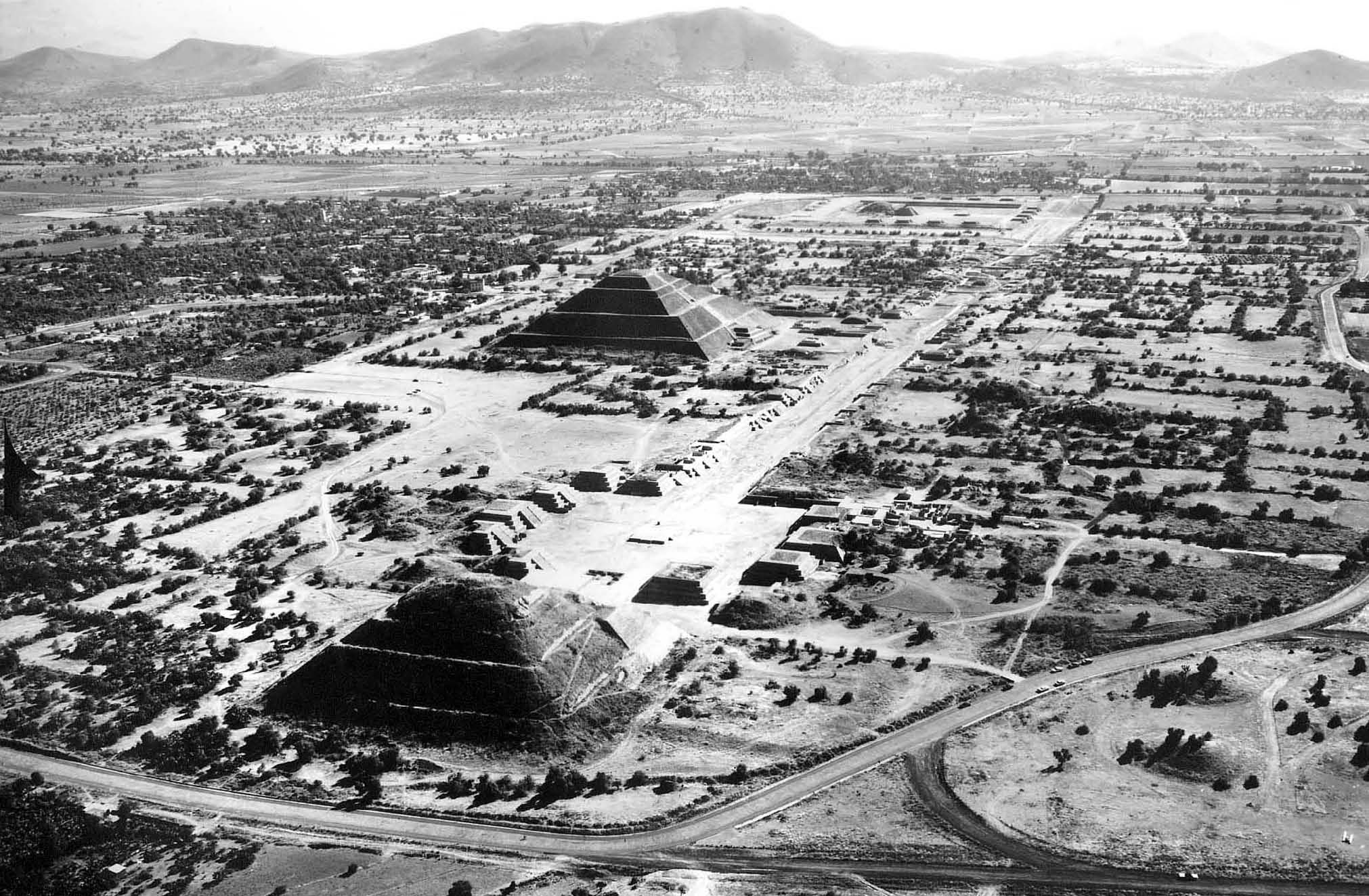
Volume 30, Issue 2: "1965 air photo of Teotihuacan, Mexico"
Photo courtesy of Companía Mexicana de Aerofoto
Covering around 20 square km and with a population around 100,000, Teotihuacan was one of the largest cities
in the ancient Americas. From around A.D. 100 – 600 this city dominated central Mexico as an economic center and capital
of a small empire. A World Heritage Site, Teotihuacan has been the setting for excavations and other archaeological research
for the past century. Archaeologists have addressed issues of urban space and society, including social class composition, spatial
zoning of foreign enclaves and other neighborhoods, space syntax of residences, and the roles of state and domestic religion.
The economy of the city has been studied including independent and state-managed craft production, commercial interactions
with areas near and far, and the city's ecological footprint ("site catchment" to archaeologists). Political topics investigated
by archaeologists include rulership and its ideological manifestations, imperial dynamics, and central planning versus
"bottom-up" processes.
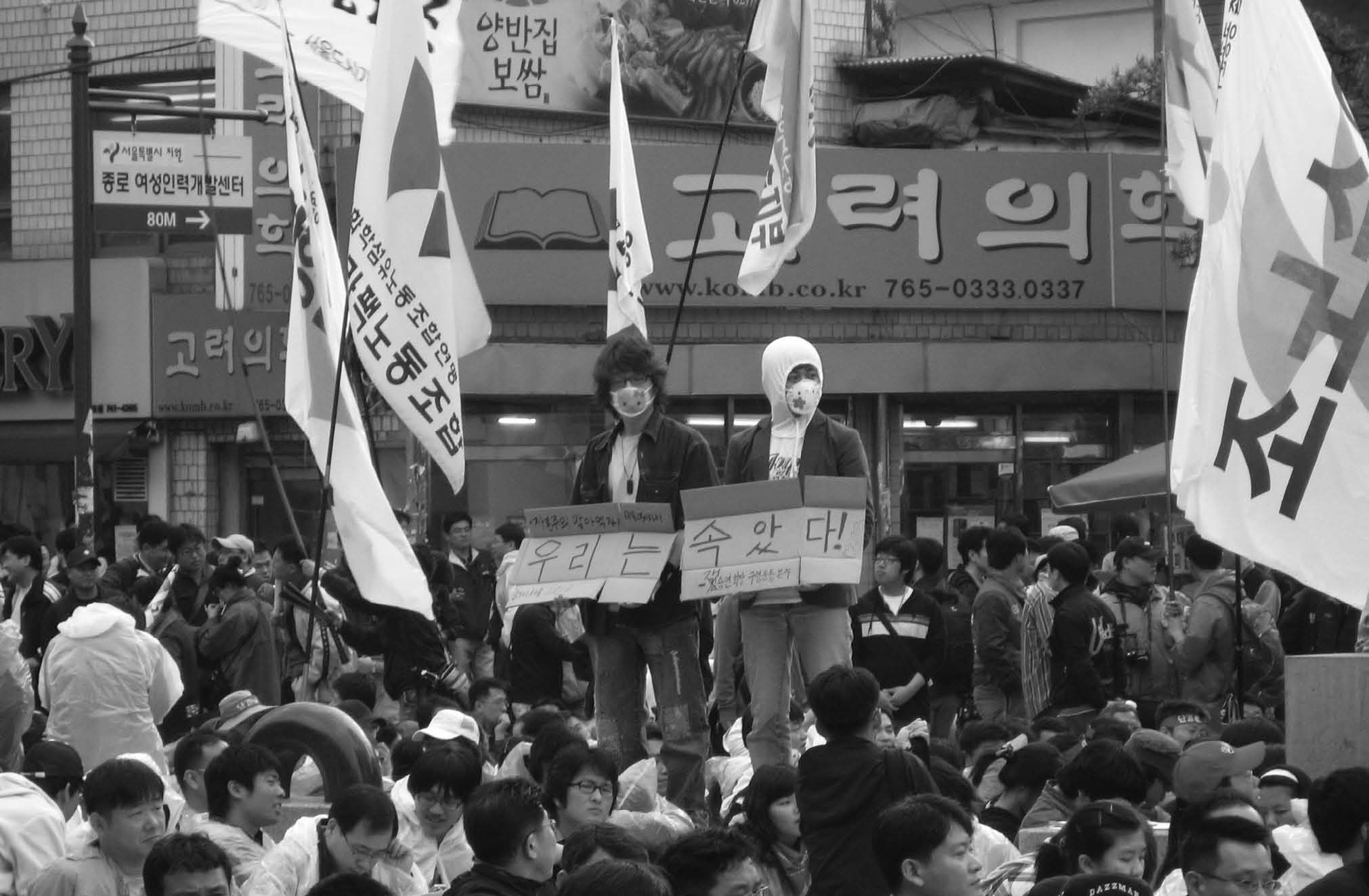
Volume 30, Issue 3: "Demonstrations in commercial areas draw little riot police attention in Korea"
Photo courtesy of Taru Salmenkari, University of Helsinki
Amidst the massive Labor Day rally in Daehangno, two Korean workers hold their own protest. Daehangno is
a historical demonstration site where protesters continue to gather even after the original reasons for staging protests there no
longer exist. During the dictatorship, when Seoul National University was still located in Daehangno, the police usually kept
out of university campuses regardless of them forming densely populated mobilization bases for demonstrations. Still today
campuses sometimes provide space for political meetings for non-students, such as striking workers, and the university gates
serve as gathering points for marches. Now Daehangno is a popular restaurant and theater area where many passers-by guarantee
visibility for demonstrations. The rally taking place in a commercial area draws little police attention. A demonstration
of this size would see an immense riot police presence near political centers of Seoul. —Taru Salmenkari, University of Helsinki 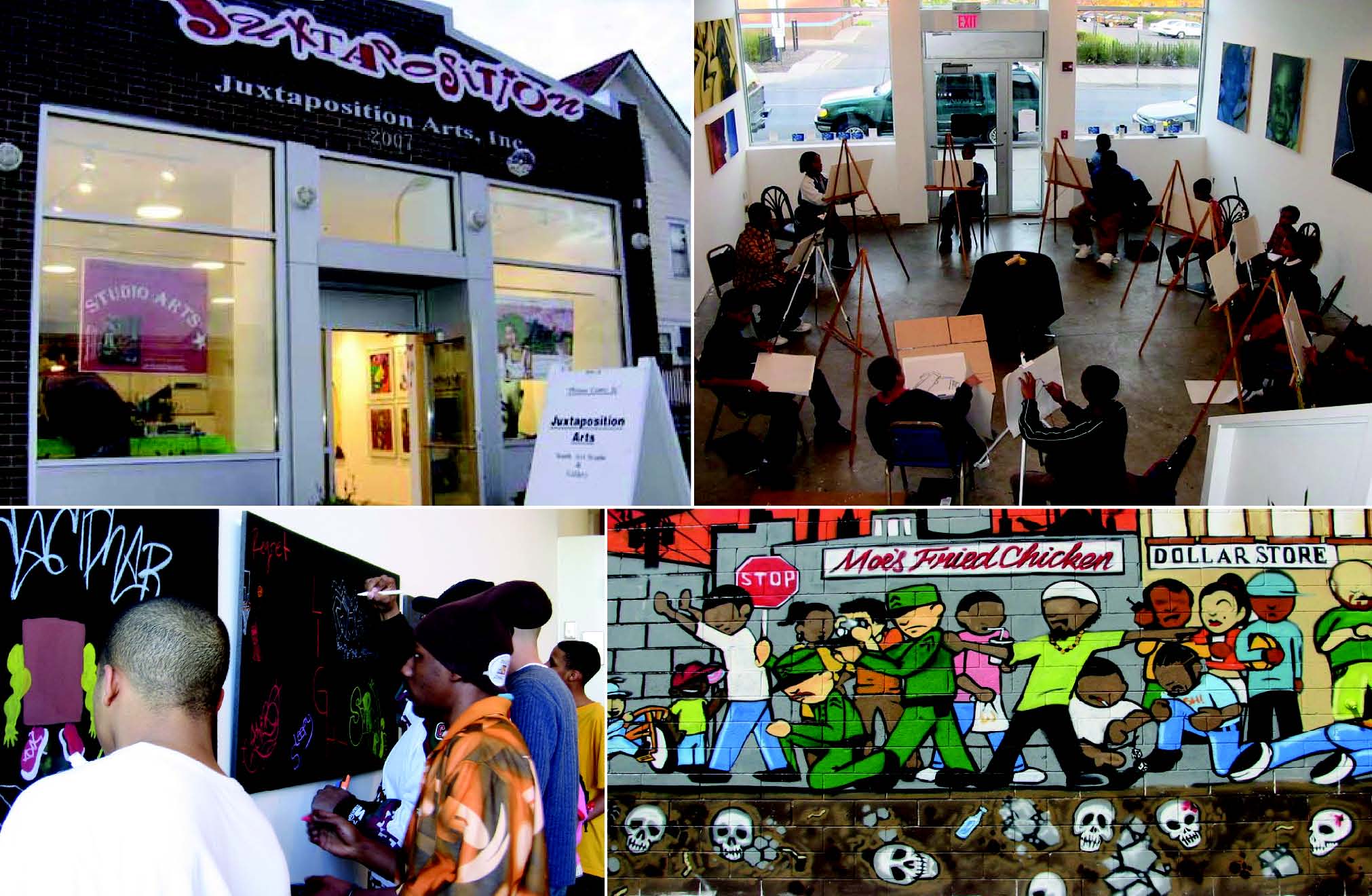
Volume 30, Issue 4: "Arts and culture as local consumption base development"
Photos courtesy of Juxtaposition Arts, Minneapolis, Minnesota
Juxtaposition Arts, a Minneapolis arts organization, nurtures urban youth in their chosen forms of visual art
expression, including Hip-Hop–inspired aerosol art. It provides them with mentoring, equipment, audiences, business skills,
connections to new networks, and a neighborhood place to convene. The name, Juxtaposition, captures the intent of founders
Roger and DeAnna Cummings to merge urban art and fine art. Their programs expose young people to a fine arts foundation,
including art history, critique, and interpretation, in addition to helping young people build careers as artists. Juxtaposition
engages local, regional, and international audiences through public festivals, symposiums, and exhibitions. Juxtaposition Arts
exemplifies how local consumption base activities generate economic and community development. Remix: Creating Places
for People on West Broadway is a collaborative project where Juxtaposition youth work with higher education institutions,
local businesses, neighborhood residents, and artists to build community pride, shared identity, and ownership of underutilized
public space in North Minneapolis. They have brought resources, expertise, inspiration, space, funding, and tourists into the
neighborhood. In Juxtaposition's role as community anchor and revitalizer, its young artists are beautifying the central corridor
and making it convivial, safe, and functional for residents and visitors. —Juxtaposition Arts, Minneapolis, Minnesota, www.juxtaposition.org 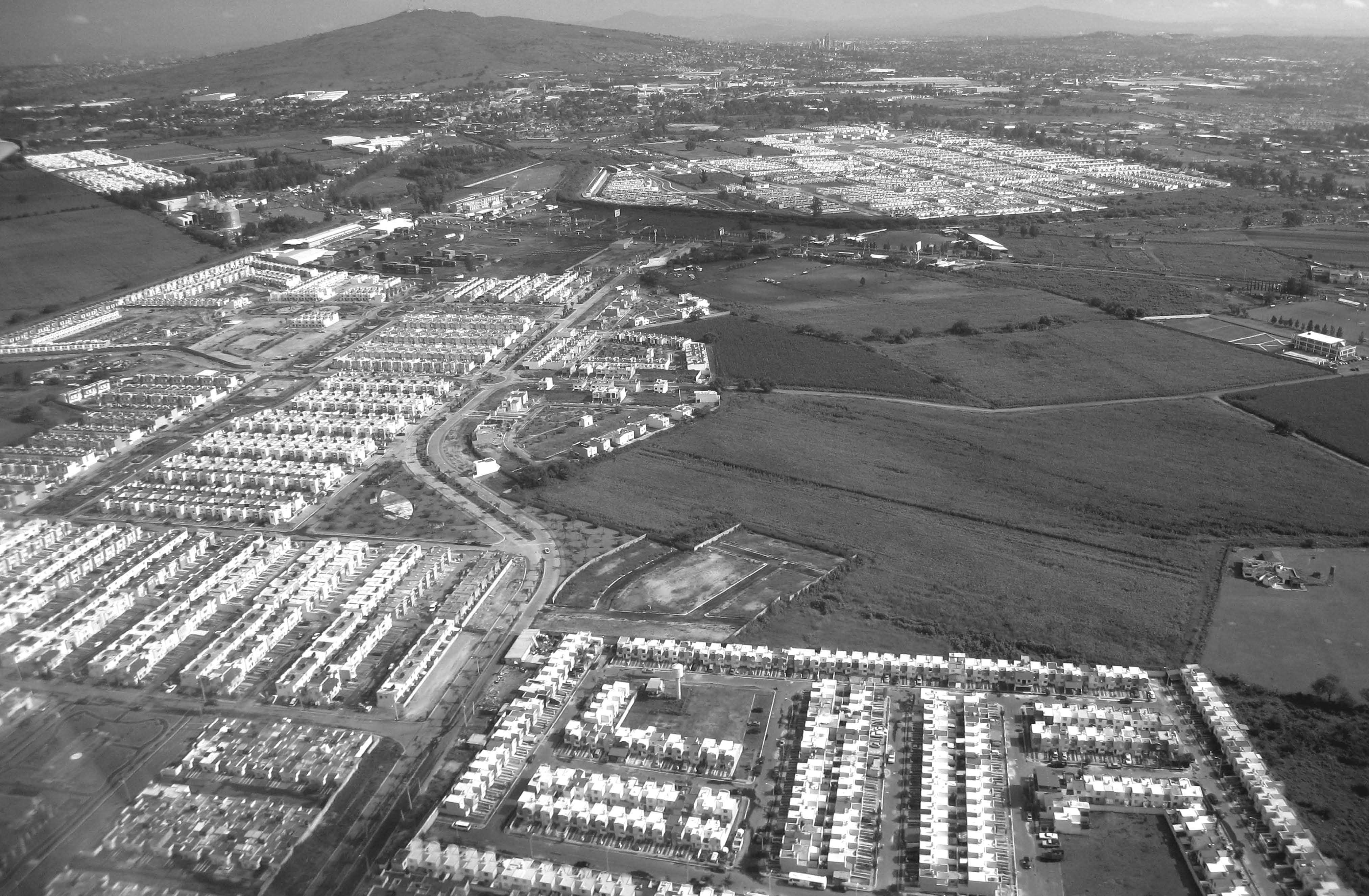
Volume 30, Issue 5: "The expansion of large tracts of social interest housing on the southwestern periphery of Guadalajara"
Photos courtesy of Edith Jiménez Huerta
Shows the expansion of large tracts of social interest housing on the southwestern periphery of Guadalajara.
The proliferation of large suburban tracts like these shown is a recent addition to the urban landscape that reflects the deregulated
housing market in Mexico. You can see that these projects occupy what was previously agricultural land. At the top, in
the background, can be seen towers near the central business district in Guadalajara. While the increased supply of housing is
much needed, the photo illustrates the separation of residential developments from the remainder of the urban fabric, and segregation
of housing from all other land uses and urban amenities—another new outcome of the neoliberal landscape in urban
Mexico. —Edith Jiménez Huerta, Universidad de Guadalajara 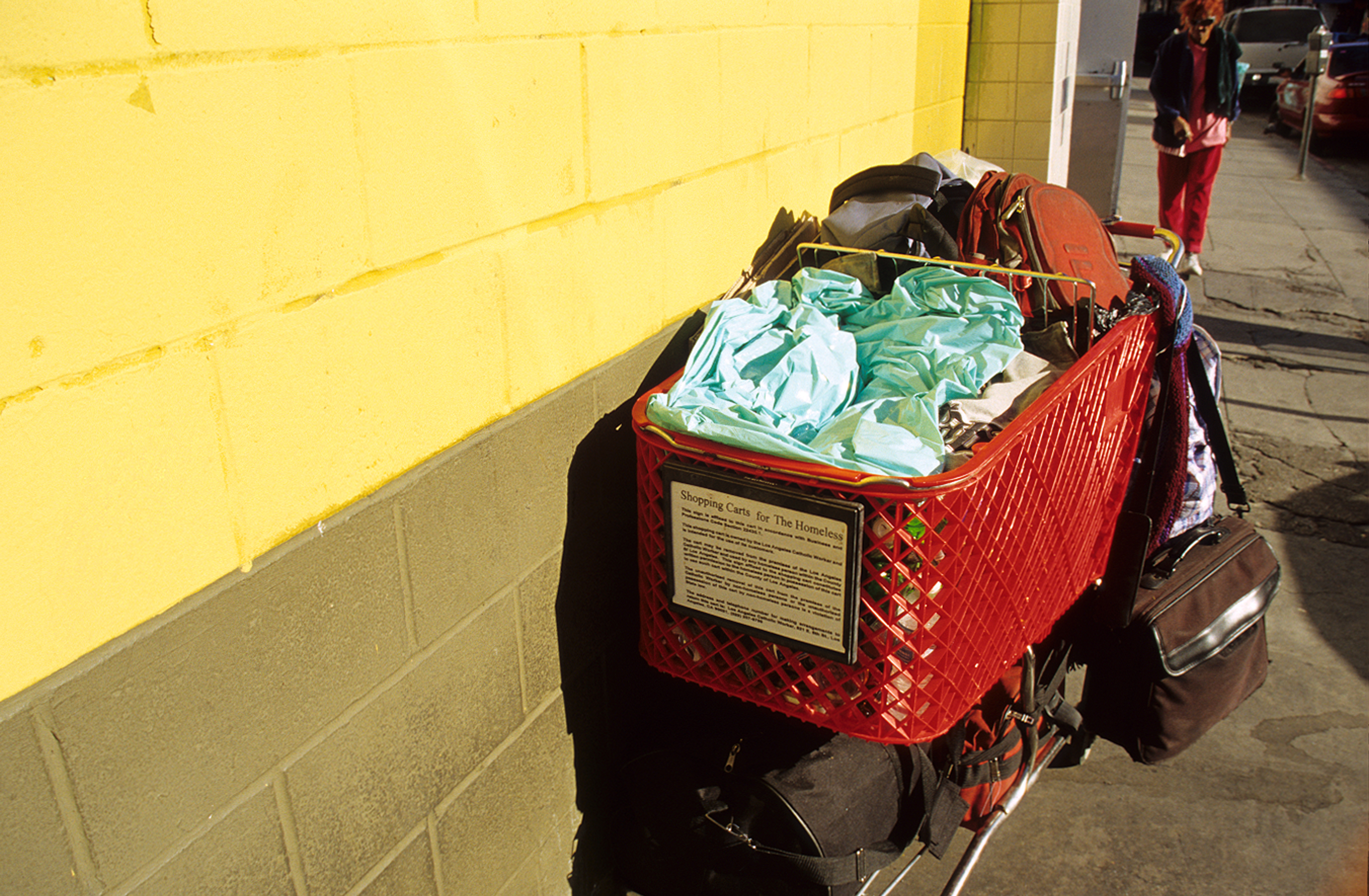
Volume 30, Issue 6: "Shopping Carts for the Homeless," Winston Street, Downtown Los Angeles, California
Photograph courtesy of Geoffrey DeVerteuil, University of Southampton
The image was taken on the outskirts of Skid Row Los Angeles in January 2009, in front of the Cardinal
Manning shelter on Winston Street. The traditional service-dependent ghetto for the Los Angeles region, Skid Row has experienced
in the past five years increasing pressure on homeless people, particularly those who remain on the streets. Police officers
have focused on anti-encampment measures, along with confiscating shopping carts which the homeless use to move
around their meager belongings, ostensibly because the carts are stolen. At the same time, however, local charities, the city,
and local businesses have been furnishing homeless people with "official " shopping carts so as to avoid police harrassment.
In a place like Skid Row Los Angeles, even something as simple as a shopping cart becomes highly politicized. —Geoffrey DeVerteuil, University of Southampton 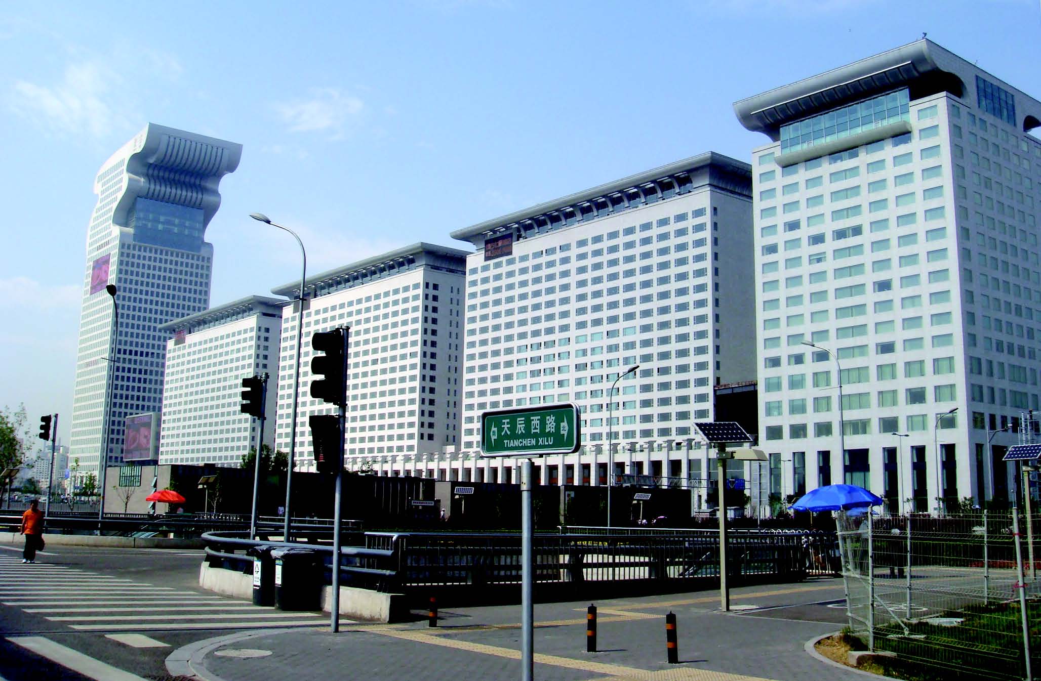
Volume 30, Issue 7: "Pangu Plaza: Dragon-Shaped Olympic Office and Hotel Complex, Beijing"
Photograph courtesy of Fahui Wang, Louisiana State University
The dragon-shaped Pangu Plaza, adjacent to the National Aquatics Center (the "Water Cube"), and the National
Stadium (the "Bird's Nest"), is a landmark office-hotel-apartment complex designed by C. Y. Lee and developed by Beijing
Pangu Investment. It consists of five white buildings: a 192-meter-high office building ("dragon head," left in the photo), a
residential complex, a 411-meter-long "dragon corridor," 85-meter-high "courtyards in the sky," and a seven-star hotel. After
the 2008 Beijing Olympics, this area has become a new commercial center in Beijing. — Fahui Wang, Louisiana State University 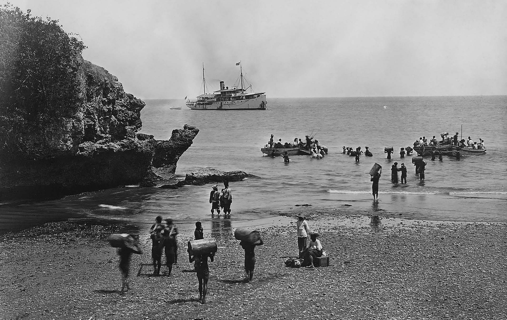
Volume 30, Issue 8: "Kupang, 1927 - Government steamer 'Gemma' being loaded off the beach"
Photograph by permission of Collection of the KITLV, Leiden, The Netherlands
Kupang, 1927 - government steamer "Gemma" being loaded off the beach. State infrastructure built in the late colonial period - radios, telephones, roads, shipping - integrated provincial towns into an emerging nation. The towns became a node in a national network of communication. — Collection of the KITLV, Leiden, The Netherlands Back to the Top
2008
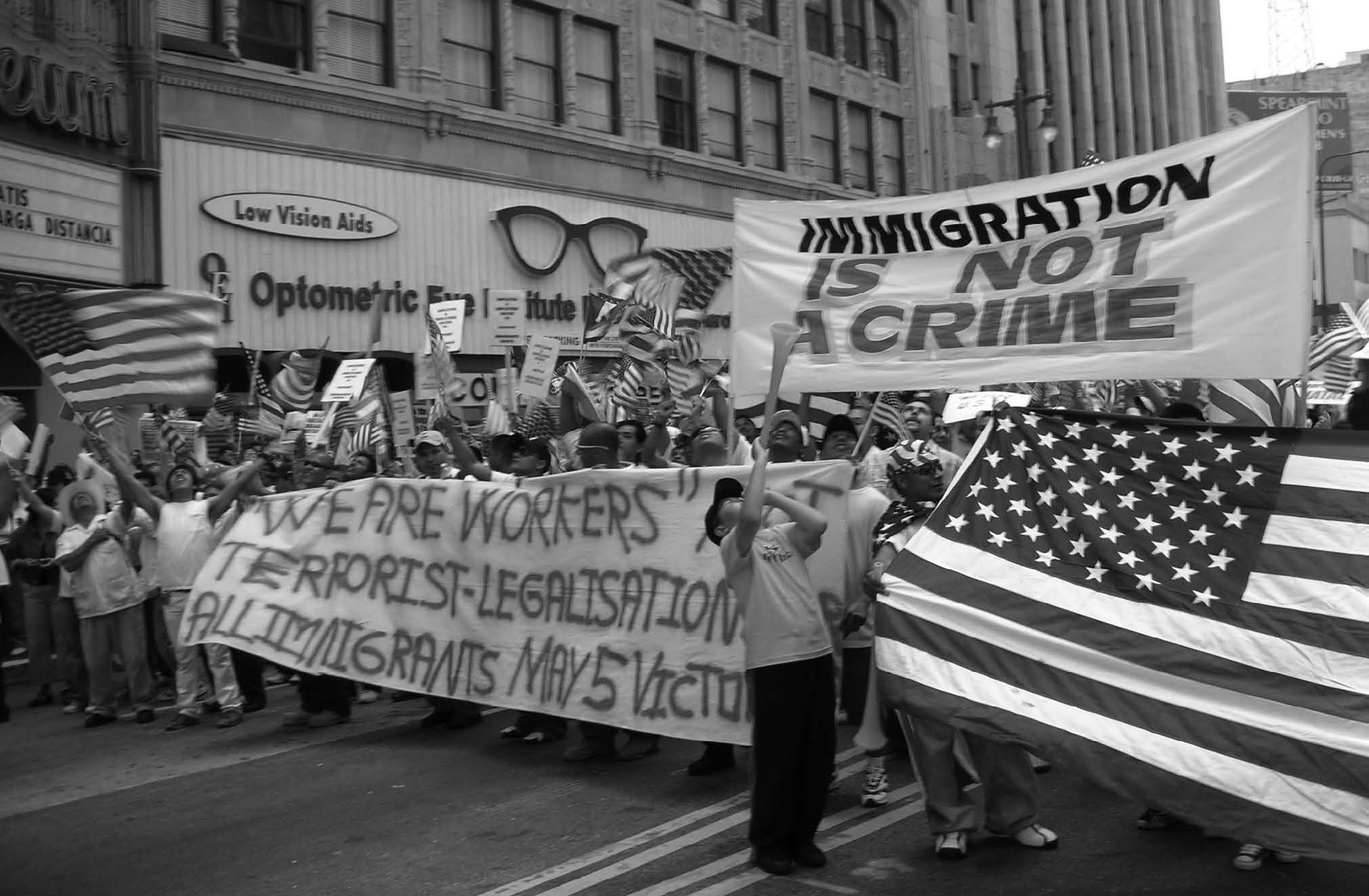
Volume 29, Issue 1: "Los Angeles, California – May 1, 2006"
Photo courtesy of Jennifer Ridgley, University of Toronto

Volume 29, Issue 2: "Urban Playground and Cultural Landscape: Millennium Park in Chicago"
Photo courtesy of Robert J. Sampson, Harvard University
Opening in the summer of 2004 as the brainchild of Mayor Richard M. Daley, Chicago's Millennium Park has
been widely acclaimed despite a rough beginning. Early critics pointed to cost overruns and charges of political corruption in
the park's construction. Initially budgeted at 150 million dollars the park's final tab was closer to half a billion. Millennium
Park has nonetheless made a splash with locals while drawing international attention to its postmodern architecture, original
public artwork, and accessible open spaces for civic engagement. Affirming the bold vision of Mayor Daley in making the
park a symbol of Chicago's cultural renaissance, tourists continue to visit in droves while nearby a building boom of residential
development has been ignited. On a sunny September day, adults and children are seen frolicking in the popular wading
pool on the west side of the park. —Robert J. Sampson, Harvard University 
Volume 29, Issue 3: "Erosion in Welezo shehia, Zanzibar, 2007"
Photo courtesy of Garth Myers, University of Kansas
A donor-funded government water development project created this gully, as water from a new borehole poured
down into the Mwembesaba informal settlement in Welezo. Mwembesaba residents suffered significant flood damages without
compensation and are subject to eviction during completion of the water project's pipeline into the city. Mwembesaba is
part of what residents sarcastically refer to as Gaza Strip, the string of informal settlements in Zanzibar's West District just
outside the municipal boundary of Zanzibar city. West District now has more urban residents than Urban District, the city proper.
More than 80% of West District's residents live in informal settlements, many of which lack basic service provision such
as water supply. Hence the photograph's grand irony: West District suffers the consequences of water development designed
for the city; the benefits of the water project will largely bypass the neighborhoods damaged in its creation. —Garth Myers, University of Kansas 
Volume 29, Issue 4: "Freedmen's Town, in the path of downtown expansion and Houston's urban revitalization program"
Photo courtesy of Igor Vojnovic, Michigan State University
A streetscape showing the traditional houses in Freedmen's Town—Houston's African-American 'mother
ward'—with the city's central business district in the background. This African-American neighborhood traces its history back
to the abolition of slavery. In the 1990s, in large part responding to Houston's downtown revitalization efforts, houses in
Freedmen's Town began to be increasingly purchased by developers. Once acquired, the houses would be boarded-up and
fenced, and when torn-down the vacant land was poorly maintained. These 'block-busting' tactics not only contributed to the
decline of Freedmen's Town but also the community's housing values. They also provided added incentive for residents still
living in the neighborhood, evident with the occupied houses down the block with cars on the street, to sell their properties.
This picture was taken in the early 2000s. These building have since been razed and the neighborhood is increasingly being
occupied by professionals living in the newly built urban lofts and townhouses. —Igor Vojnovic, Michigan State University 
Volume 29, Issue 5: "'Polish flats' located in the Riverwest neighborhood, Milwaukee, Wisconsin"
Photo courtesy of Deanna Schmidt, University of Wisconsin-Milwaukee
The Riverwest homes depicted in the photograph are locally identified as Polish flats, suggesting that this form
of building is a remnant of Polish traditions. However, these workers' cottages, built circa 1890, have little to do with Polish
vernacular architecture. Instead, the Polish flat is a manifestation of local real estate markets and aspirations for homeownership
among the working class. Local building and real estate speculators built small, one-story workers' cottages to meet the
growing housing demand as Milwaukee industrialized during the late 19th century. Families, many of whom were Polish-
American but not all, purchased these standardized, economical homes. To accommodate their growing families and/or generate
rental income needed to repay the mortgage, homeowners literally raised the cottage and built a second housing unit
below. This form of incremental building was common in Milwaukee's working class neighborhoods like Riverwest. —Deanna Schmidt, University of Wisconsin-Milwaukee 
Volume 29, Issue 6: "Remnant housing of sedentary Romani community in Sulukule neighborhood, central Istanbul"
Photo courtesy of Helga Leitner, University of Minnesota
Two of the few remaining houses in the Sulukule neighborhood, home to one of the world's oldest sedentary
Romani communities, nestled inside the city walls of the historic center of Istanbul. Sulukule's deteriorating building stock
was scheduled for demolition, as part of the municipality's urban renewal project in 2007. For further details on the future of
the neighborhood and its residents see the Urban Pulse contribution by Ozan Karaman in this issue.. —Helga Leitner, University of Minnesota 
Volume 29, Issue 7: "International architecture in Oviedo, Spain, 2008"
Photo courtesy of Richard Shearmur, Université du Québec
Further to Bilbao's (and other cities') apparent success at attracting international attention through innovative
architecture designed by a big name architect, the city of Oviedo in northern Spain is attempting something similar. Located
in a residential district, with some facades only a few dozen feet from residential apartment buildings, will this Congress and
Shopping centre (which will also house some provincial administrative offices), place Oviedo on the international map, and,
if so, whose map? According to the promoters of the shopping centre, "this complex [designed by Santiago Calatrava]… is
already admired and is already being studied by architects, engineers and artists from all over the world" (Immo-news.net,
2008). —Richard Shearmur, Université du Québec 
Volume 29, Issue 8: "Abandoned home in North Minneapolis, Minnesota"
Photo courtesy of Jeff Crump, University of Minnesota
In the predominantly African-American neighborhood of North Minneapolis, MN abandoned homes dot the
landscape. Many of these structures were investment properties where owners used subprime loans to extract large profits from
property. The remaining residents now bear the brunt of massive devaluation brought on by irresponsible lending and vulture
capitalism in the form of fraudulent investment schemes. —Jeff Crump, University of Minnesota Back to the Top
2007
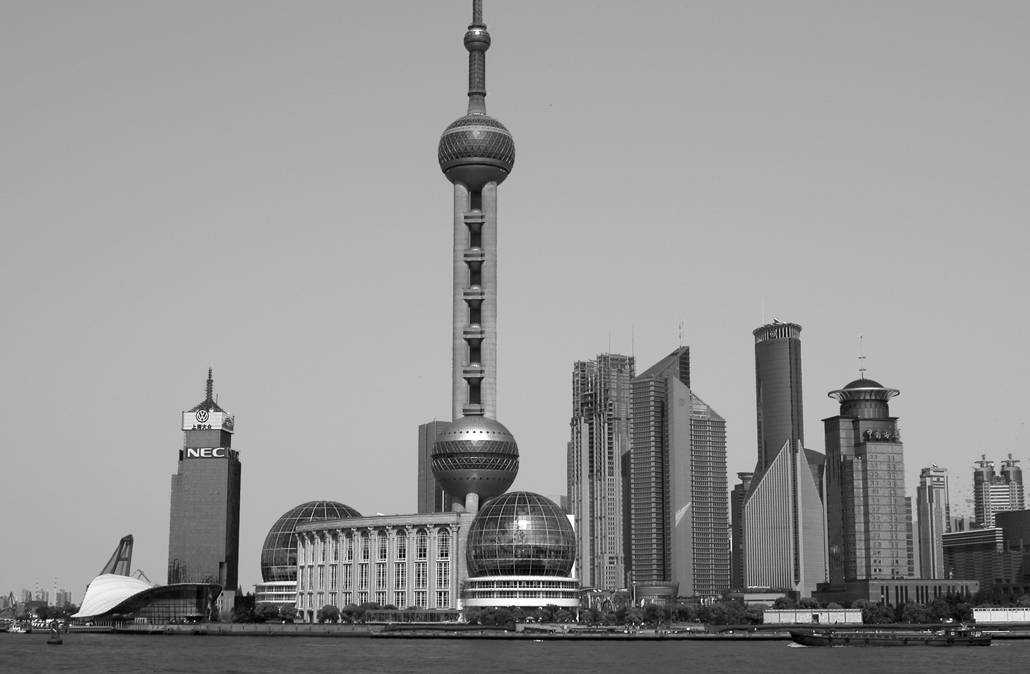
Volume 28, Issue 1: "New Cityscape in the Pudong Urban District in Shanghai, China, 2006"
Photo courtesy of George C. S. Lin, The University of Hong Kong
After practicing the socialist strategy of industrialization with controlled urbanization for decades, Chinese
cities have since the 1990s experienced profound social and spatial transformation as a consequence of increased marketization
and globalization. Urbanism has been actively pursued as a strategy of place-promotion. One of the outstanding examples
has been the creation of The New Pudong Urban District from scratch in Shanghai-China's Dragon Head-as the symbol
of modernity and urbanism seemingly comparable to the Western world. —George C. S. Lin, The University of Hong Kong 
Volume 28, Issue 2: "Cars parked among the industrial ruins of Atlanta's Cotton Mill Lofts"
Photo courtesy of Katherine Hankins, Georgia State University

Volume 28, Issue 3: "Santa Cruz de Tenerife (Canary Islands, Spain). Santiago Calatrava Auditorium, old Church of Regla Virgin"
Photo courtesy of L. M. García Herrera and M. A. Mejías Vera, University of La Laguna, Spain
The picture symbolizes the history of the urban transformation of the waterfront. Redevelopment takes place
over and amidst a local history of conflict and injustice. Expensive new cultural and leisure facilities, such as the Santiago
Calatrava Auditorium, are built as symbols of the new city which strives to become an attractive urban destination for visitors
and investors; on the other side of the road the Church of Regla Virgin turn into the traditional gathering place for displaced
residents of erased neighborhoods. —Luz Marina García Herrera, University of La Laguna, Spain 
Volume 28, Issue 4: "An under-mountain garage in Salzburg, Austria"
Photo courtesy of David W. Wong, George Mason University
Parking is a problem mostly in large cities, but it could also be a problem in cities where space is limited due
to various physical constraints, such as rugged terrain or the presence of rivers. In Salzburg, Austria, because the Salzach River
dissects the City surrounded by mountains, there is little land in the city for parking. An innovative solution is to go under the
mountains for parking space – a slightly different version of the underground garages found in many large cities. —David W. Wong, George Mason University 
Volume 28, Issue 5: "A road separating neighborhoods in contested urban space: Lod, Israel"
Photo courtesy of Erez Tzfadia, Sapir College, Israel
This is a photo of a road between Pardes-Sanir (on the right) – an informal Palestinian neighborhood, and Ganey
Aviv (on the left) – a new neighborhood of Russian immigrants. Ganey-Aviv was planned in order to prevent Pardes-Sanir
from spreading out beyond the road and as part of a series of attempts to maintain a Jewish majority in the city by supplying
affordable housing for Jewish immigrants. Ganey-Aviv is forbidden to Palestinian residents. Erez Tzfadia and Haim Yacobi
argue in their article that the planning, construction and settlement of Ganei-Aviv near the Palestinian-informal neighborhood,
are clear indicators to the newly arrived Russian immigrants of where exactly the border lies between 'us' and 'them'. Indeed,
the road in the photo symbolizes this border. Thus the road demonstrates the process by which a group of immigrants is simultaneously
inserted and inserting itself into multiple relationships within contested societies. Here, ethno-national logic forms
the urban reality. —Erez Tzfadia, Sapir College, Israel 
Volume 28, Issue 6: "Gentrification as a means of segregation"
Photo courtesy of Ravit Goldhaber, Ben Gurion University
Andromeda Hill is one of the most exclusive residential projects in Israel situated in the northern part of the
Arab neighborhood Ajami - one of the poorest neighborhoods of Tel-Aviv-Jaffa. It is a gated community of very wealthy people,
Jewish only, segregated from the world of Jaffa. The project is part of a gentrification process that has been taking place
in Tel-Aviv-Jaffa since the late 80s, and is part of the globaliization Zunami that is sweeping the world. The gap between the
marginalized Arab community with its deteriorated houses and the modern Andromeda Hill dwellings is an outgrowth of economic,
cultural and national tensions in Jaffa. This picture illustrates as it were a benign process of gentrification, yet beneath
the surface it hides spatial-perceptual segregation, urban discrimination policies, excluded and marginalized ethnic groups and
urban ethnocracy. —Ravit Goldhaber, Ben Gurion University 
Volume 28, Issue 7: "Businesses speak your language in Elmhurst, NY"
Photo courtesy of Arun Peter Lobo, Population Division, New York City Department of City Planning
The Lavida pharmacy in Elmhurst, in Queens County, New York City, sits in a census tract where nearly 8-outof-
10 residents are foreign-born and where over 60 percent of the population has limited English proficiency. Hispanics and
Asians together account for most of the population of nearly 11,000. Colombians, Ecuadorians, and Mexicans comprise the
majority of Hispanics, while Chinese, Asian Indians, Filipinos, and Koreans are the largest Asian groups. This ethnic mélange
has helped make Queens County the most diverse county in the U.S. In such a multiethnic setting, successful businesses and
institutions have learned to reach out to an array of ethnic and language groups. The international language collection of the
Elmhurst public library, for example, has materials in Spanish, Chinese, Tagalog, Korean, and in four Asian Indian languages.
The Lavida pharmacy too knows how to be welcoming in such a multiethnic setting: It speaks your language. —Arun Peter Lobo, Population Division, New York City Department of City Planning 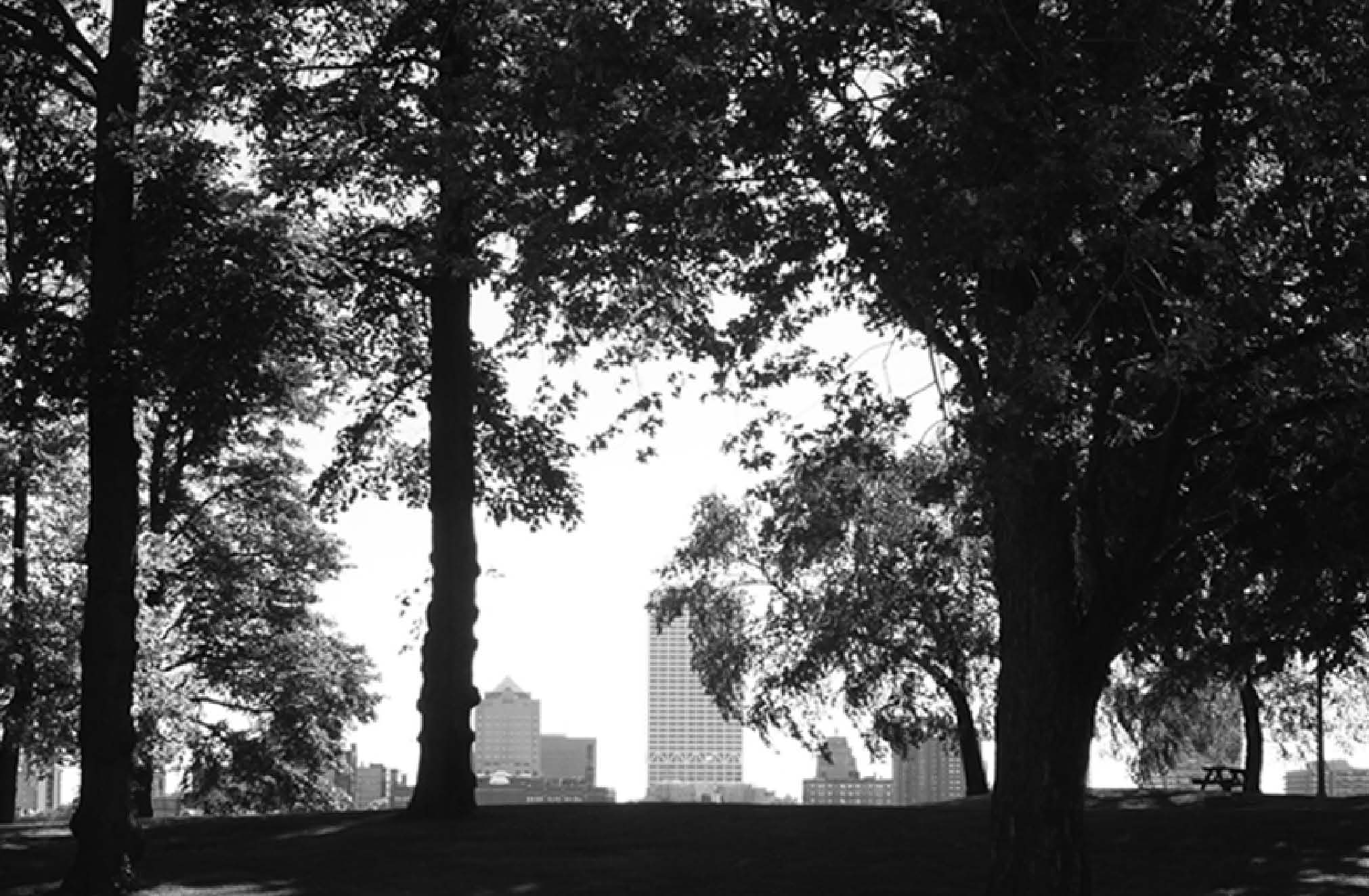
Volume 28, Issue 8: "A (un)natural connection between trees and skyscrapers"
Photo courtesy of Harold A. Perkins, Ohio University
Are these trees standing in Milwaukee's Kilbourn Park more 'natural' than the tall buildings they foreshadow?
At first glance the answer is an unequivocal yes. But a black and white photograph of trees against the city's skyline removes
the verdant filter that colors such over-simplified perceptions of the urban environment. In grayscale these trees are more readily
recognized as urban amenities socially constructed within the political and economic circumstances from which the concrete
and glass structures behind them sprang forth. A central task for urban environmental geographers is therefore to theorize
that- like skyscrapers- trees represent the uneven concentration of material wealth based on racial, ethnic, and socio-economic
characteristics of localities. This is no small endeavor as we have a difficult time seeing the unjust forest for its beautiful
trees; ironically it is the urban forest's own aesthetic that effectively masks the 'unnatural' relations behind its uneven
production and distribution. —Harold A. Perkins, Ohio University Back to the Top
2006
Volume 27, Issue 1: "Chinatown and Little Italy's North Beach, San Francisco, California"
Photo courtesy of Qingfang Wang, The University of North Carolina at Charlotte
Since the 1950s San Francisco has been evolving from a blue-collar port city of manual labor and material
goods to a white-collar center of finance, administration, tourism and the "knowledge industries." Even so, ethnic enclaves
still provide significant cultural and economic dynamics to this vibrant urban landscape. As shown in the picture, Chinatown,
on the right side, and Little Italy's North Beach on the left, are two of San Francisco's oldest and most colorful neighborhoods.
Signs on neighborhood restaurants and small shops reflect this blend of cultures as told in different languages. Juxtaposed with
the modern Transamerica Pyramid not far behind, the tallest in San Francisco, these neighborhoods are in the forefront of a
picturesque combination of both ethnic neighborhoods/workplace and the major financial district within the same general
urban space. Thus, San Francisco vividly demonstrates a global economy based within a local urban geography. —Qingfang Wang, The University of North Carolina at Charlotte 
Volume 27, Issue 2: "Low-income residents tap main power lines, Santo Domingo, the Dominican Republic"
Photo courtesy of Petronella Muraya, Howard University
In Santo Domingo, the Dominican Republic, the low-income settlements of La Pińa and Lebrón are undergoing
upgrading with the construction of new housing units. The latter are structures made of durable building materials, the
units also have running water and sewage but lack electricity, and residents make up for this by tapping the main power lines
as shown on the photo and they do not have to pay for the utility. This is a strategy employed by the low-income throughout
the city and it has come at a high cost. The overloaded power lines often lead to blackouts in the city and to cope with the
problem generators are used as backup when the power goes out. Lack of sufficient financial support in the housing project
has meant that the new units do not come with all the necessary basic services such as electricity and residents are forced to
make up for this by tapping the main power lines. —Petronella Muraya, Howard University 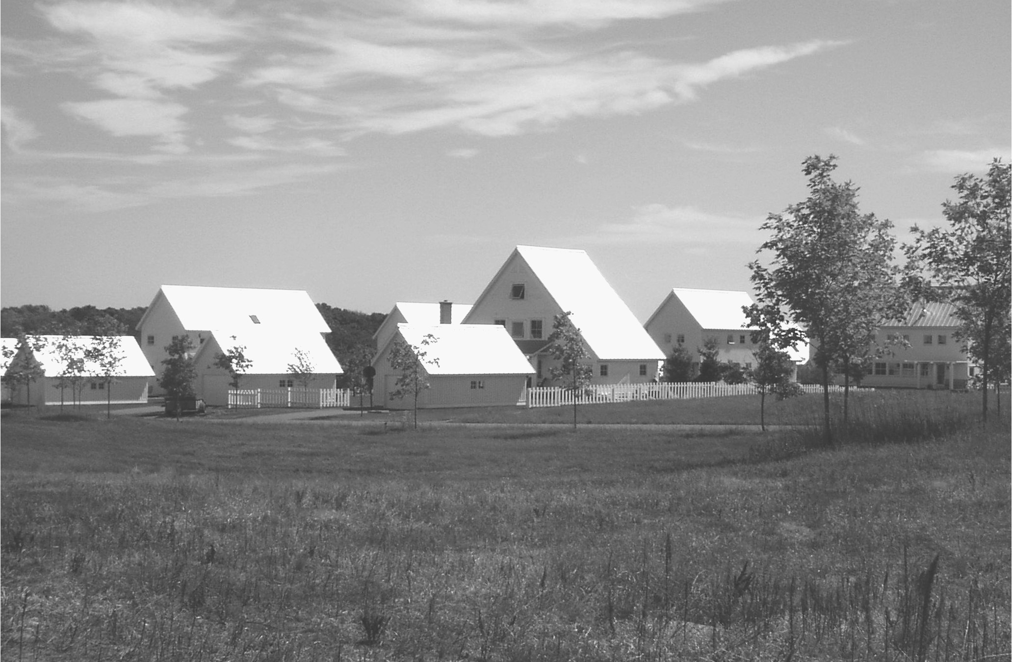
Volume 27, Issue 3: "Jackson Meadow: a conservation subdivision in Marine on St. Croix, Minnesota"
Photo courtesy of Mark Bjelland, Gustavus Adolphus College
Numerous "smart growth" prescriptions have been promoted to reform the suburban project. One of the smart
growth strategies applicable to outer suburban areas is that of conservation subdivisions which allow some residential development
but preserve the look of the landscape by clustering houses together and leaving much of the site in an undeveloped
state. Conservations divisions such as the Jackson Meadow development shown in this view have become a popular near the
St. Croix River valley on the eastern fringes of the Minneapolis-St. Paul metropolitan area. This development will feature
sixty-four houses clustered together and surrounded by 250 acres of restored natural prairie. While the developers of Jackson
Meadow stress environmental sensitivity and sense of community in their marketing, this project, like other alternative suburban
developments, embodies a number of contradictions and raises questions about what is being conserved and for whom. —Mark Bjelland, Gustavus Adolphus College 
Volume 27, Issue 4: "Inner city canal, Amsterdam"
Photo courtesy of Piet Musterd
The inner city of Amsterdam is still a very important area in economic and in residential terms. It is the most
important shopping, leisure and tourist area of the city, while major financial and other institutions can be found in attractive
parts of the main canals. While new economic centres were developing far from the old city centre, this did not result in a
deterioration of the inner city. In the 1960s and early 1970s there were plans to demolish parts of the inner city and link the
most central parts of town with wide roads or even highways to the rest of the region. These plans, however, were abandoned.
Today it would be unthinkable that such plans would even be discussed. Recently, this part of town appears to have become
most attractive for new creative industries. This offers new opportunities for the future of the inner city. —Sako Musterd, Universiteit van Amsterdam 
Volume 27, Issue 5: "New restaurant in the district of Mladost, Sofia, Bulgaria"
Photo courtesy of Sonia Hirt, Virginia Polytechnic Institute and State University
This photo is taken in Mladost—one of the largest housing districts in the Bulgarian capital of Sofia. The district was developed under the communist regime in the 1970s and 80s and comprises hundreds of repetitive residential buildings
in the Modernist style located amid vast green spaces. Today, the district has become the sight of radical visual contrasts.
Upon the backgrounds of the grey, rather dull buildings from the communist era, one finds a startling variety of styles and
functions—from fast food restaurants to Western-style malls and from gated communities to Eastern-style bazaars. At the forefront
of the photo is one building which adds further stylistic spice to the area—a new restaurant erected to emulate traditional
Bulgarian residential architecture from the 18th and 19th centuries. The name of the restaurant is in fact The Spice [Пикант].
—Sonia Hirt, Virginia Polytechnic Institute and State University 
Volume 27, Issue 6: "Housing Inequality in Beijing"
Photo courtesy of Youqin Huang, State University of New York, Albany
The picture was taken in the western suburb of Beijing – Haidian district, which is a district known for numerous
high education and research institutions, and rising high-tech industries. The front of the picture features the traditional
housing in Beijing – courtyard house, which is often characterized with the lack of modern facilities such as bathrooms,
crowdedness, and the lack of maintenance. While providing shelter to poor native Beijing residents and poor migrants from
the countryside, these courtyard houses are also used for small business such as shoe repair and bicycle repair, convenience
stores and small eateries. The background is new high-rise apartment buildings and office buildings for professionals. —Youqin Huang, State University of New York, Albany 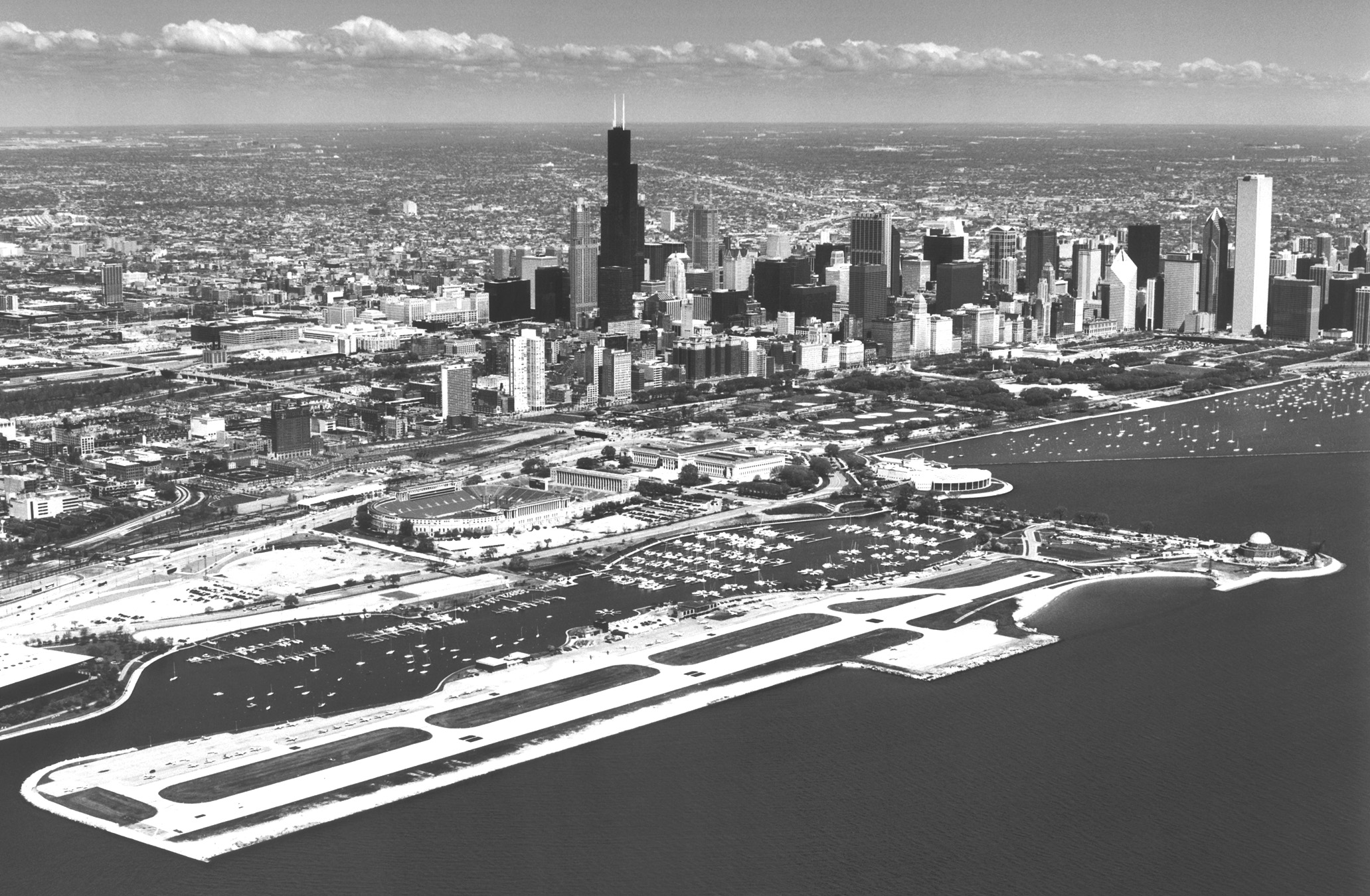
Volume 27, Issue 7: "Chicago's Meigs Field airport in 1997 (closed in 2003)"
Photo © Marge Beaver (www.photography-plus.com)

Volume 27, Issue 8: "Sign of the Times? Mexico's Maquiladoras"
Photo courtesy of Robert South, University of Cincinnati
Mexico is one of the world's most important locations for manufactures for export (maquiladoras). In 2000,
there were more than 1.3 million employees, a record for the maquila industry, and a year later there were 3,735 maquilas, a
record number of plants. From 2001 to 2004, however, 820 maquilas closed, the largest number of plant closures in the history
of export manufacturing in Mexico. Maquila closure has abated in recent years but the events of 2001-2004 may well portend
the future of the industry. Maquilas are located in 341 urban places (1990-2000) generating significant local employment
and collectively generating the second-largest source of foreign exchange. There are, however, significant variations in plant
closure among urban places suggesting that maquila closure is not systemic. Mexico cannot compete for export manufactures
on the basis of a waning comparative advantage, cheap wages; rather the future of maquiladoras is a different manufacturing
paradigm. —Robert South, University of Cincinnati Back to the Top
2005

Volume 26, Issue 1: "Vietnamese Shopping Center in Suburban Virginia"
Photo ©Rob Crandall Photography (www.robcrandall.com)
Eden Center, a Vietnamese shopping center in Falls Church, Virginia, is the most important central place for
Vietnamese goods and services on the East Coast. It is also located in a suburban area where Vietnamese immigrants have
clustered in metropolitan Washington. This community has its roots to refugees flows in the 1970s, especially after the fall of
Saigon in 1975. The community asserts its political identity by retaining the flag of the former South Vietnamese Republic
along side the U.S. Flag. Such ethnically distinct commercial centers that serve a growing and diverse immigrant population
are found throughout metropolitan Washington. —Marie Price, George Washington University, Washington, DC 
Volume 26, Issue 2: "Changing Residential Landscapes in Shanghai"
Photo courtesy of Fulong Wu, University of Southampton, United Kingdom
Inside the central city of Shanghai, the recent building boom has accelerated the demolition of old lane housing
and the construction of new high-rises. The dynamic succession of urban residential structure from dilapidated lilong (lane
housing) to high-rises or condominiums has been accompanied by changes in the social composition of subdistricts and neighborhoods
in the city and greater socio-spatial differentiation. The photo, taken near "New Heaven on Earth" (Xin Tian Di),
shows the conversion of a small tract of lane housing to recreational and high-end retail uses (foreground), against the backdrop
of massive high-rise construction. This new round of inner-city redevelopment has transformed residential landscapes
under the joint forces of Shanghai's greater internationalization and economic restructuring. —Fulong Wu, University of Southampton, United Kingdom 
Volume 26, Issue 3: "Residential Construction in China's Suburbs"
Photo courtesy of Jian Feng, Peking University, China
In the suburbs of China's large cities, a large number of residential buildings have been constructed in recent
years, especially since the 1990s. These buildings include ordinary commercial housing, luxurious villas often purchased by
the affluent, and economical housing, which refers to the housing built under favorable terms from government and sold to
low- and medium-income buyers. The fact that more and more parks, shopping malls, schools, and hospitals are located in
China's suburban residential quarters makes the suburbs more attractive to many people, especially the affluent and the young.
The average housing price in China's suburban area is much lower than in the urban core. As a result, many urban residents
have moved to the suburbs and increasingly more new housing buyers tend to choose the suburbs. Under these circumstances,
suburbanization has accelerated since the 1990s. —Jian Feng, Peking University, China 
Volume 26, Issue 4: "Late Soviet apartments in Ust'-Kamenogorsk, Kazakhstan"
Photo courtesy of Michael Gentile, Stockholm School of Economics, Sweden
The cities of the Soviet Union were characterized by a chronic housing shortage
which hampered the development of the spatial structure of the "socialist" city as it was envisaged in theory. In fact, although
the newly built self-contained neighborhood units (the so-called mikrorayony) were supposed to include basic infrastructure
and services to be used on a daily basis, the housing shortage meant that the construction of new dwellings took precedence
over everything else, resulting in an increasing delay between the provision of housing and the provision of the necessary
neighborhood amenities. In many cases, the latest Soviet housing developments were left unfinished and, much to the distress
of their inhabitants, the post-Soviet local authorities cannot afford to prioritize their completion. This photograph of a late
Soviet high-rise development in Ust'-Kamenogorsk, Kazakhstan, provides an illustrative example of this problem —Michael Gentile, Stockholm School of Economics, Sweden 
Volume 26, Issue 5: "Steel mill effluent enters Lake Michigan on the southeast side of Chicago, 1930"
Photo courtesy of Chicago Park District Special Collections
The southeast Chicago industrial district was the scene of several important interstate pollution controversies.
Illinois sued Indiana to block discharges from fouling Lake Michigan water which was Chicago's drinking water supply in the
early 20th century. In the 1950s, a federal suit against Republic Steel was the first use of the 1899 Rivers and Harbors Act for
water pollution concern. Later, a federal conference attempted to curtail interstate pollution in the southern section of Lake
Michigan. —Craig E. Colton, Louisiana State University, Baton Rouge, Louisiana 
Volume 26, Issue 6: "Emergency Homeless Shelter, Mesa, Arizona"
Photo courtesy of Ayona Datta, London School of Economics, United Kingdom
A view of the emergency homeless shelter located in Mesa, Arizona. In the foreground is the children's playarea
with the smoking area on the right and the laundry behind it. In the background are the studios for the homeless families.
Restructured from a rundown motel, this shelter sits in an area surrounded by trailer parks, cheap motels, and car dealerships,
which is also one of the weakest economic areas in the city. This emergency shelter is unique in the way it provides a range
of facilities to homeless families through both its physical and social environments. The studios provide a complete domestic
setting including living/sleeping area, full bathroom, kitchen, as well as basic furniture and appliances. The complex also has
a range of facilities such as daycare center, children's play areas, library, laundry and so on. —Ayona Datta, London School of Economics, United Kingdom 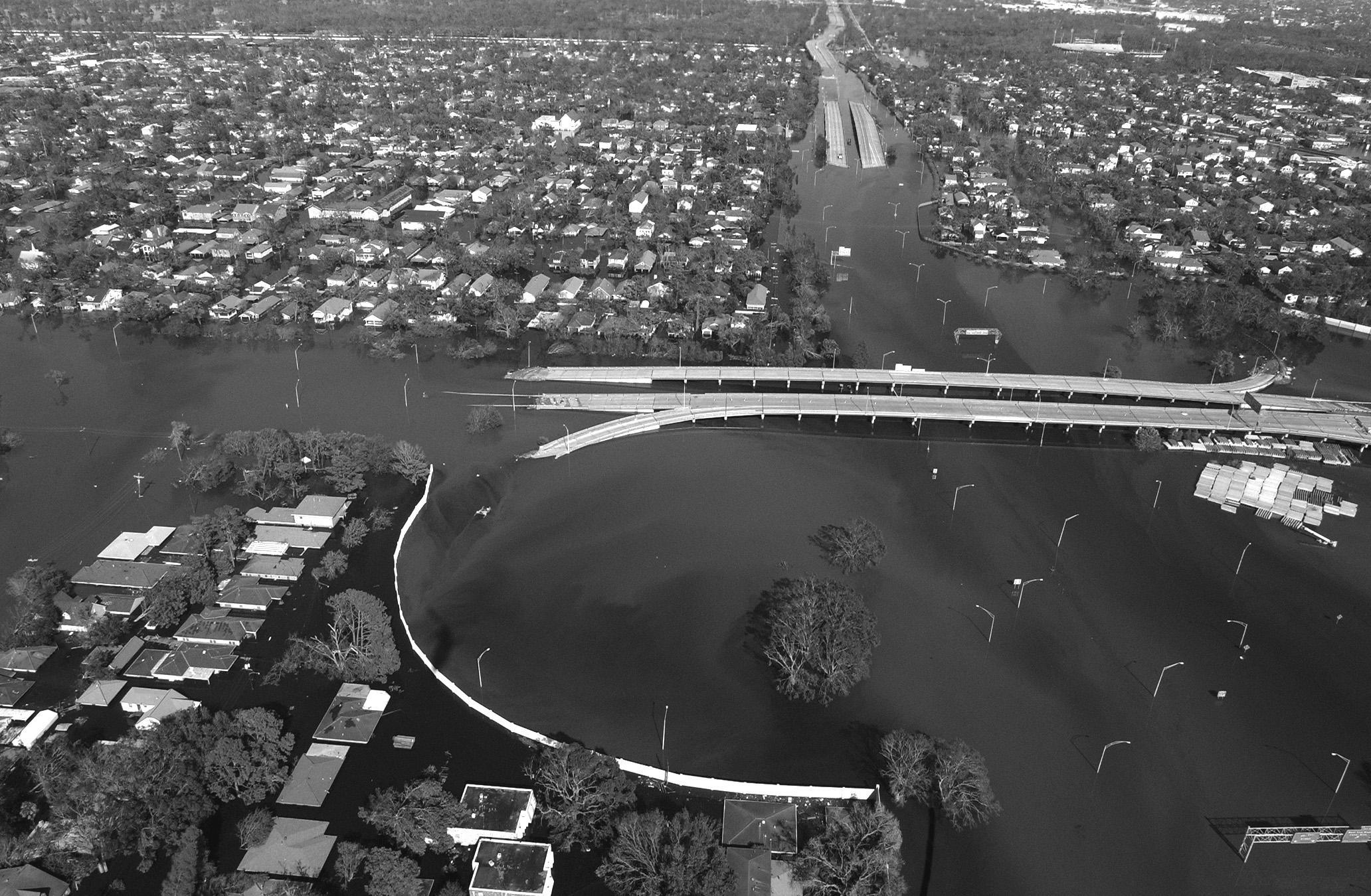
Volume 26, Issue 7: "New Orleans, Louisiana, September 7, 2005, following Hurricane Katrina"
Photo courtesy of Jocelyn Augustino/Federal Emergency Management Agency (FEMA)

Volume 26, Issue 8: "Gated Housing in Accra, Ghana"
Photo courtesy of Richard Grant, University of Miami
Back to the Top
2004
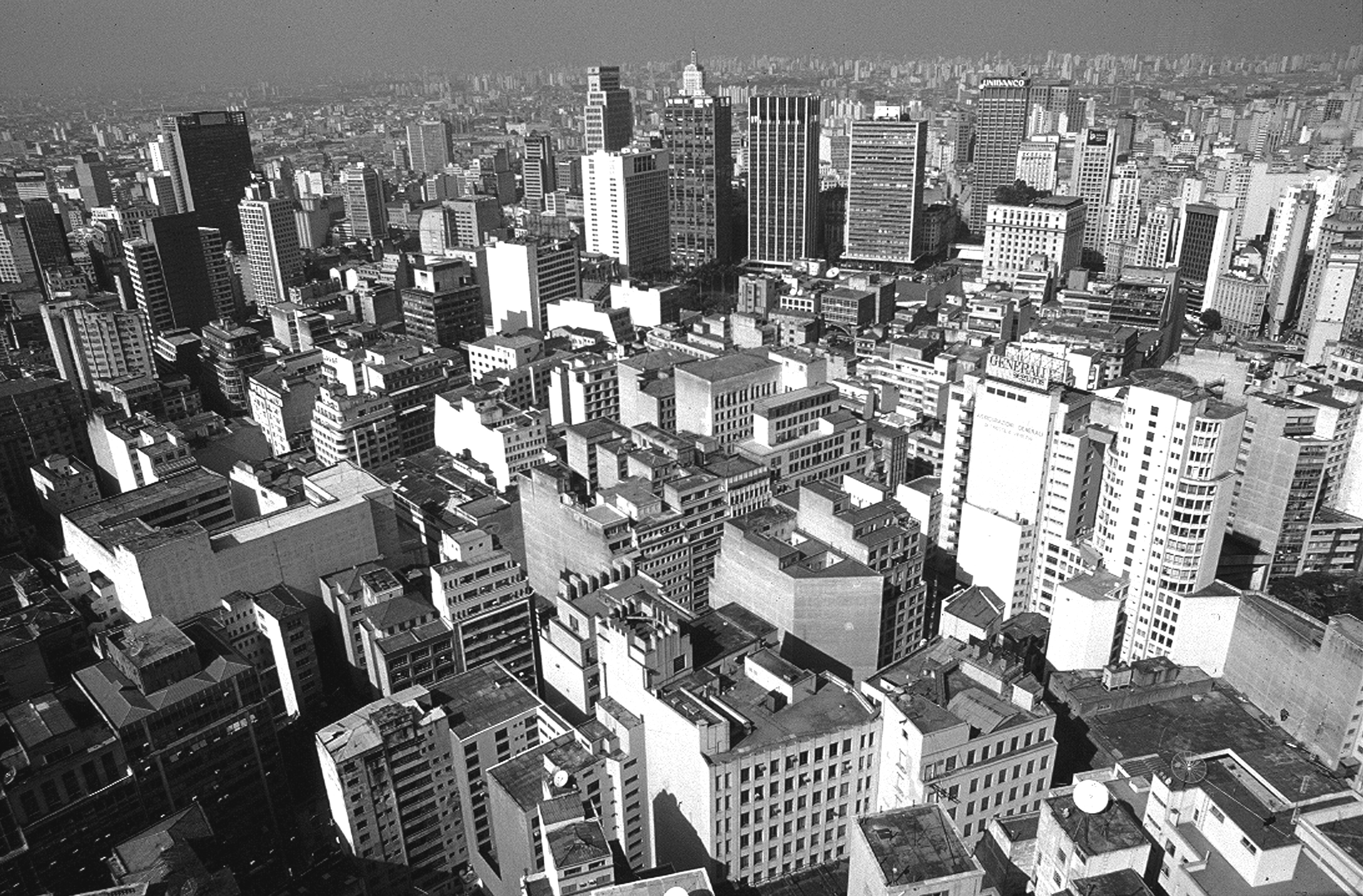
Volume 25, Issue 1: "The high-density sprawl of Sao Paulo, Brazil"
Photo courtesy of Geoffrey DeVerteuil, University of Manitoba
Like many mega-cities in the less developed world, Sao Paulo faces enormous challenges in accommodating
relentless population growth. The solution apparent in this image (taken from the tallest building in Sao Paulo, the Edificio
Italia) is unplanned high-density sprawl, through which the jagged metropolis inexorably extends both outwards and upwards.
Despite its attributes as a dynamic, diverse and globalized city-region, Sao Paulo undeniably resembles Blade Runner -the
wealthiest now routinely commute by helicopter- and is predicted to overtake Canada in terms of population within the next
fifteen years. —Geoffrey DeVerteuil, University of Manitoba, Winnipeg, Manitoba, Canada 
Volume 25, Issue 2: "Tower Bridge, London, United Kingdom"
Photo ©2004 www.clipart.com
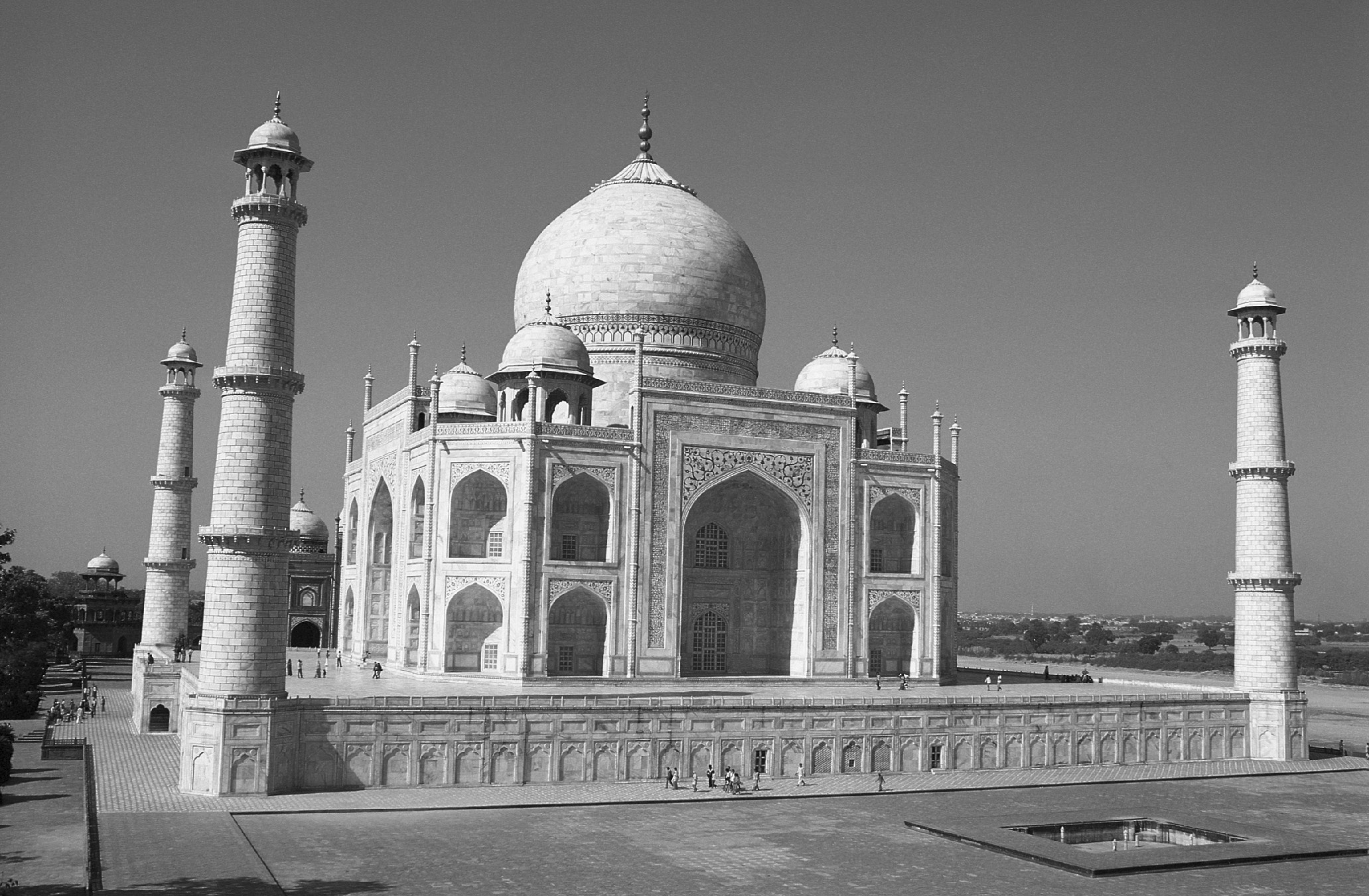
Volume 25, Issue 3: "Taj Mahal, India"
Photo ©2004 www.photos.com

Volume 25, Issue 4: "Contemporary Images of the Midlands"
Photo courtesy of Rosemary Taylor, Edgbaston, Birmingham, United Kingdom
"Contemporary Images of the Midlands" – Rosemary Taylor blends traditional photographic techniques with
computerized image manipulation to produce distinctive pictures of the places where she lives. Her current work strives to capture
the feeling, emotion and unique history of the place that is the English Midlands today. Rosemary grew up in Norfolk and
studies photography at the Regent Street Polytechnic in London. Since 1988, she has exhibited in London, Birmingham,
Norfolk and on the South Coast. Rosemary now lives and works in Edgbaston, Birmingham. —Rosemary Taylor, Edgbaston, Birmingham, United Kingdom 
Volume 25, Issue 5: "Neighborhood change in Seoul, Korea"
Photo courtesy of Philip Gersmehl, University of Minnesota, Twin Cities
Seoul, Korea, is one of the fastest growing and most densely populated urban areas in the world. Near many
stops on the extensive transit system, planned developments of high-rise apartments are replacing crowded neighborhoods of
houses and small apartments. In this view from a platform on the line to Ouijonbu, a man carrying a large sack is walking
down an older street that is too narrow for most trucks. The tiled roofs of the surrounding houses feature many attempts to
modernize the old structures: garden pots, electric lines, propane tanks, evaporative coolers, airconditioners, satellite receivers,
and even a few solar-energy collectors. The photographer has a question: which of the neighborhoods in this photo is best
poised to enter an age of more expensive energy? —Philip Gersmehl, University of Minnesota, Twin Cities, Minneapolis, MN 
Volume 25, Issue 6: "Revitalized downtown in Missoula, Montana"
Photo courtesy of Rina Ghose, University of Wisconsin-Milwaukee
The small town of Missoula, located among the Rocky Mountains of Western Montana, has experienced rapid
population growth in the last decade and has emered as a metropolitan area in the 2000 Census. A significant section of these
newcomers have preferred the revitalized downtown as their playground. Once the site of vacant buildings and declining fortunes,
the downtown buildings have been renovated and restored to their former glories and house art galleries, pricey boutiques,
expensive antique stores, gourmet food stores, and stylish upscale restaurants. Working-class bars and cheap restaurants
that once dotted the landscape have been edged out through high rents. The downtown represents Missoula's changing
image and demographics. —Rina Ghose, University of Wisconsin-Milwaukee, Milwaukee, WI 
Volume 25, Issue 7: "Tax-forfeited brownfield site in Minneapolis, Minnesota"
Photo courtesy of Minnesota Pollution Control Agency
A zone of industrial discard has developed in a ring surrounding the central business district of many cities. In
this view, the Warden Oil site in North Minneapolis is shown as it looked when public officials first explored the site after it
was forfeited to Hennepin County for delinquent property taxes. The site was used to recycle waste oils from 1927 to 1992.
When it reverted to Hennepin County, the site contained ten deteriorating buildings and over 100 above ground tanks and several
underground tanks filled with process chemicals. Soils and groundwater were contaminated with petroleum, lead, and
PCBs. The site is located in a floodplain, 200 feet from a stream, and bordering a low-income, mostly non-white neighborhood.
Tax-forfeited brownfield sites such as Warden Oil combine the worst of environmental contamination and disinvestment.
The Warden Oil site received an EPA Brownfields pilot grant in 1998 and the environmental cleanup was completed in 2005. —Mark D. Bjelland, Gustavus Adolphus College, Saint Peter, Minnesota 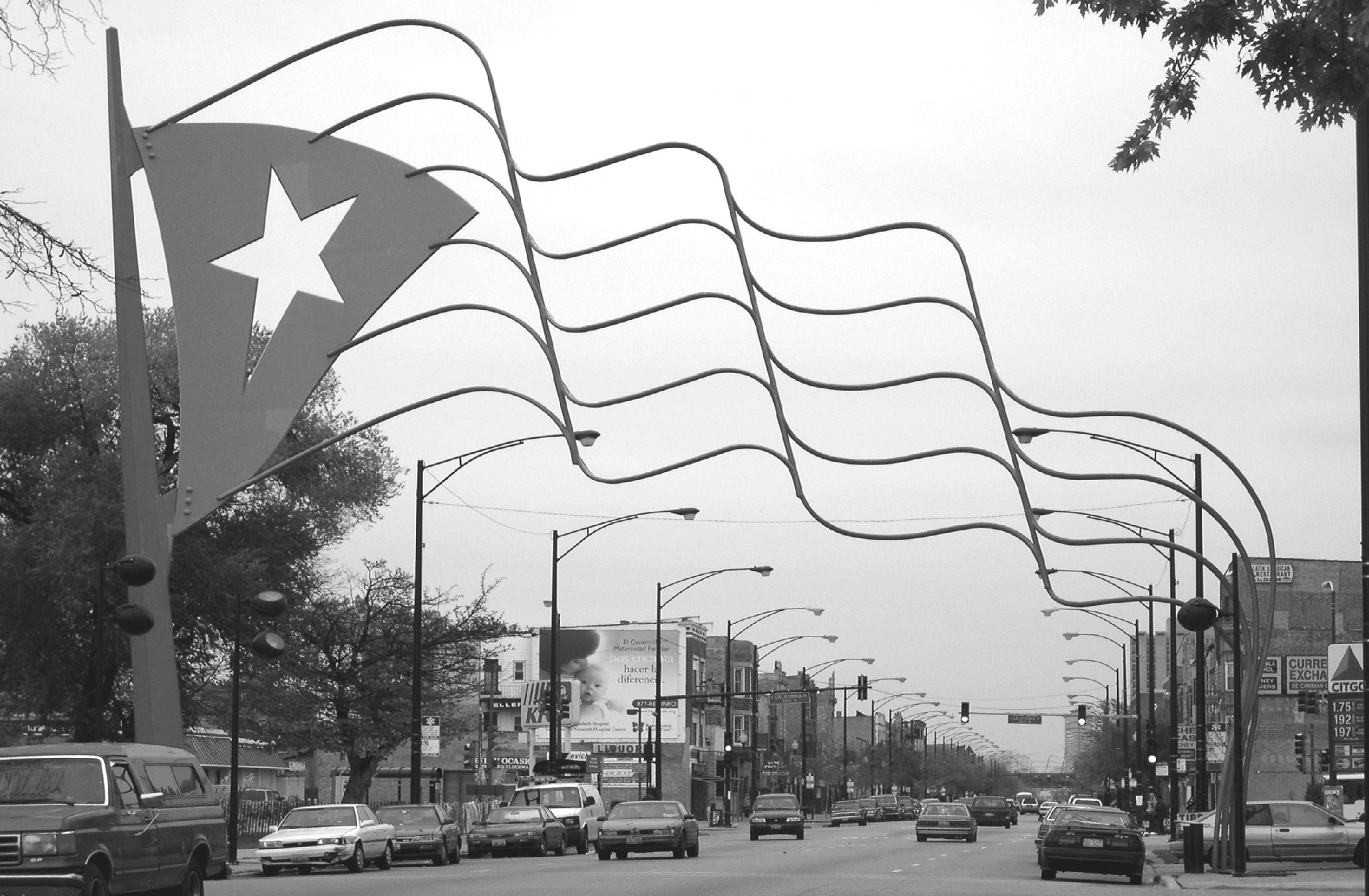
Volume 25, Issue 8: "Paseo Boricua, Chicago, Illinois"
Photo courtesy of Sarah Elwood, University of Arizona
The photo shows one of two flag monuments that bound Paseo Boricua, a stretch of Chicago's Division Street
that many consider to be the cultural and economic center of its Puerto Rican community. Erected in 1995, the monuments
were planned and implemented by neighborhood residents, community organizations, local businesses, and local government.
Paseo Boricua and other areas in and around Humboldt Park are home to a wealth of creative community activism and urban
redevelopment activities directed toward poverty, retention of industrial employers, gentrification, affordable housing, public
school policy, and youth and family services. Many of these efforts are coordinated by a coalition of community agencies, the
Humboldt Park Empowerment Partnership. The large number of community organizations in Humboldt Park and broad scope
of their revitalization strategies present an interesting empirical laboratory for better understanding the shifting role and power
of community organizations in the urban spatial politics of U.S. cities. —Sarah Elwood, University of Arizona, Tucson, Arizona Back to the Top
2003
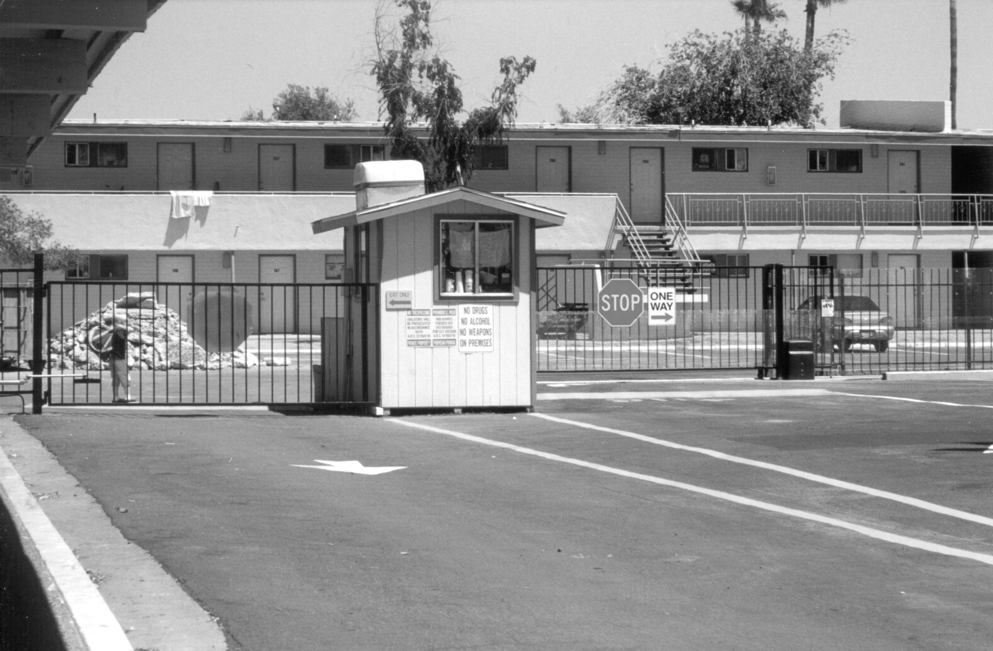
Volume 24, Issue 1: "Family Emergency Shelter in Phoenix, Arizona"
Photo courtesy of Sarah J. Brinegar, Marshall University
Located in a renovated motor inn along a stretch of highway known for prostitution, drug trade, and violence,
the pictured homeless shelter provides the largest number of beds for homeless families in the Phoenix area. At first glance,
the shelter's image differs little from similar gated/fenced complexes across the metropolitian area ostensibly built to exclude
outsiders and protect residents. But the guard and fencing that surrounds the homeless compound are effective barriers to
entry, enforcing shelter curfew and visitation rules. The barrier symbolizes the dual mission of most homeless shelters, to provide
safe shelter in dangerous locales while re-socalizing and controlling deviant homeless populations. —Sarah J. Brinegar, Marshall University, Huntington, West Virginia 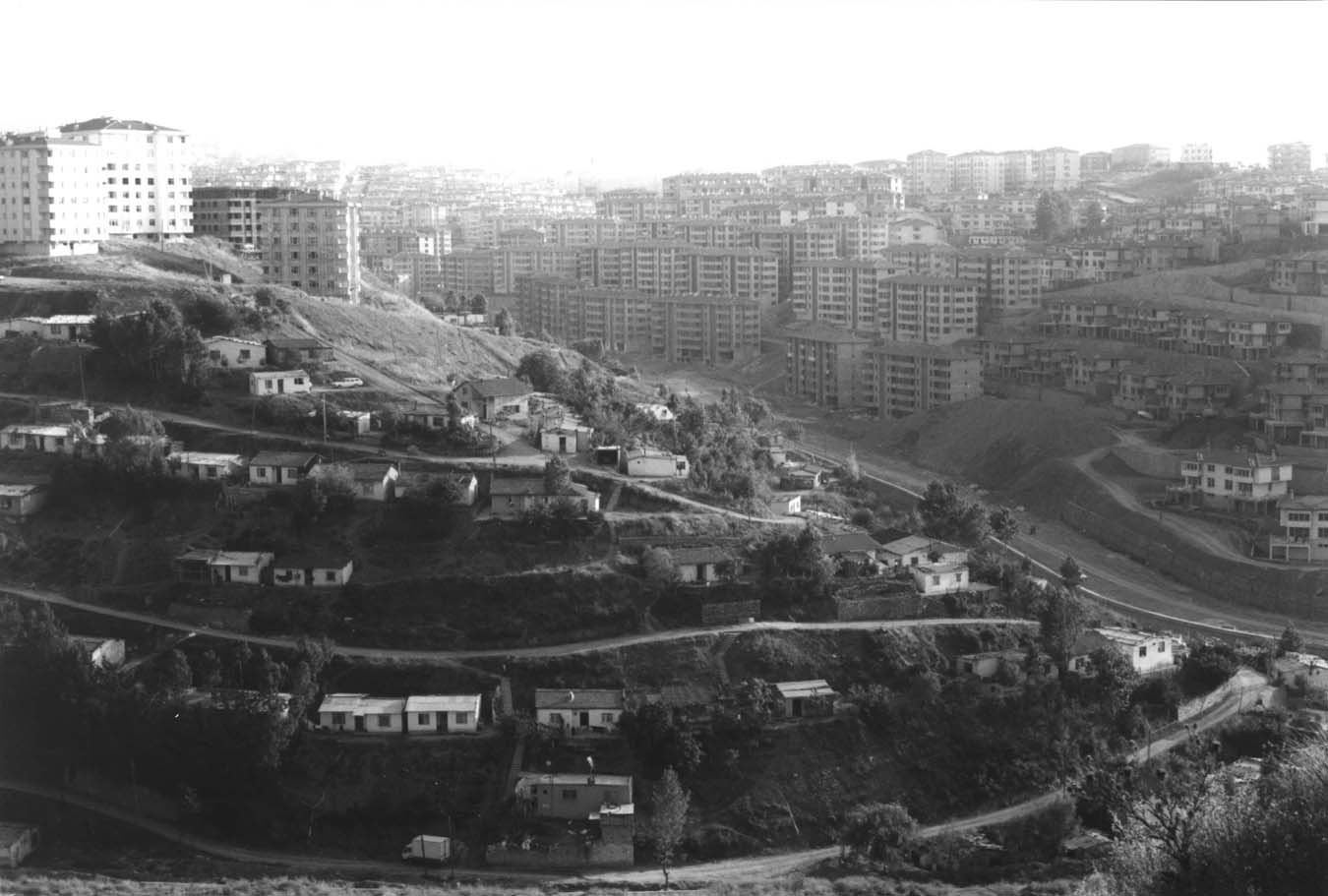
Volume 24, Issue 2: "District of Ümraniye, Istanbul, Turkey"
Photo courtesy of Anna J. Secor, University of Kentucky
Istanbul, a city of approximately 12 million, receives almost a quarter million migrants from other parts of
Turkey each year. Since becoming a municipal district in 1963, Ümraniye has absorbed many of these migrants. In the 1990s,
the population of Ümraniye almost tripled, reaching over 600,000 residents by 2000. In defiance of police, migrants set up
dwellings on unoccupied (often state owned) land. These settlements are called gecekondu, literally meaning "built up at
night." In election years, gecekondu dwellers who have established relationships with urban powerbrokers exchange their
political support for the deeds to the land on which they have built their homes. As the city expands and housing remains
scarce, this land becomes valuable for development. Gecekondu landowners may build their own apartment buildings and
become landlords, or they may sell the land to developers. This photo shows one such liminal space in Ümraniye, where high
density apartment buildings have been built on the edges of the metropolis. The small houses on the hillside will probably not
remain for long. —Anna J. Secor, University of Kentucky, Lexington, Kentucky 
Volume 24, Issue 3: "Toronto"
Photo ©2001-2002 www.arttoday.com

Volume 24, Issue 4: "Housing Contrasts in the Central Ward of Newark, New Jersey"
Photo courtesy of Kathe Newman, Rutgers University
The urban landscape encompasses contrasting worlds in close juxtaposition. In the background is Newark's
Stella Wright Homes, a public housing project comprising seven 13-story buildings built in 1959 and demolished in 2002. The
foreground shows part of the Community Hills Condominium Townhouses built by Newark's New Community Corporation,
the nation's largest nonprofit community development corporation. Designed as a model of affordable homeownership, the
two- and three-bedroom homes are priced not to exceed 35 percent of the buyer's annual income. Nonetheless, few are within
reach of the 764 households that occupied Stella Wright prior to its demolition. —Robert W. Lake, Rutgers University, New Brunswick, New Jersey 
Volume 24, Issue 5: "Musée du Louvre, Paris, France"
Photo ©2003 www.clipart.com

Volume 24, Issue 6: "Residential subdivision development near Stevenson Ranch, northern Los Angeles County, California"
Photo courtesy of Michael Dear, University of Southern California
Sprawl has hit the wall in Los Angeles, in the sense that the limits of developable land are rapidly being
approached. One solution is to leap over the surrounding mountains into nearby deserts or into the Central Valley of California.
Another (more common) solution is to cut the tops off surrounding mountains, and use the displaced materials to fill in the
adjacent valleys, thus providing graded sites perfect for more sprawl. Either way, Los Angeles simply does not have sufficient
land to accommodate a population growth of six million persons anticipated during the next 20-25 years, unless current land
development practices are radically altered. —Michael Dear, University of Southern California, Los Angeles, California 
Volume 24, Issue 7: "Observing Beijing's ancient observatory"
Photo courtesy of J. Andrew Walcott
Beijing's ancient observatory, constructed on city walls between 1437-1446, features astronomical instruments
introduced by Matteo Ricci and Ferdinand Verbiest in the 17th century. Now on a busy street in the diplomatic section, contemporary
observers can see both Chinese style and tall modern buildings eclipsing the old watchtower —Susan M. Walcott, Georgia State University, Atlanta, Georgia 
Volume 24, Issue 8: "Winter Palace, St. Petersburg, Russia"
Photo courtesy of Andrew R. Bond
The Winter Palace, St. Petersburg, Russia (from Palace Square). Winter residence of Imperial Russia's royal
family during much of the period when St. Petersburg, Russia's "western window," was the capital (1712–1918), the Winter
Palace symbolizes both Russia's pre-communist past and its ambivalent orientation toward the West. In the late 18th century,
it was expanded to house what became the opulent Hermitage Museum, a showcase of imperial wealth, and its seizure by
Bolshevik forces on November 8, 1917 is viewed as a dramatic event of the Russian Revolution. Following the disintegration
of the USSR, and especially after the accession of native son Vladimir Putin to the Russian presidency in 2000, St. Petersburg
has experienced a boom in new construction, commercial development, housing renovation, and tourism, as local boosters
resumed the competition with Moscow for political influence, Western investment, and international prestige. Early in the
Putin presidency, a proposal was floated to relocate the Russian parliament in St. Petersburg, and in May 2003, a series of summit
meetings between Russian officials and foreign dignitaries (EU officials and U.S. President Bush) marked the tricentennial
of the city's founding. —Andrew R. Bond, Bellwether Publishing, Ltd. Back to the Top
2002

Volume 23, Issue 1: "Baltimore's Inner Harbor"
Photo ©2001-2002 www.arttoday.com
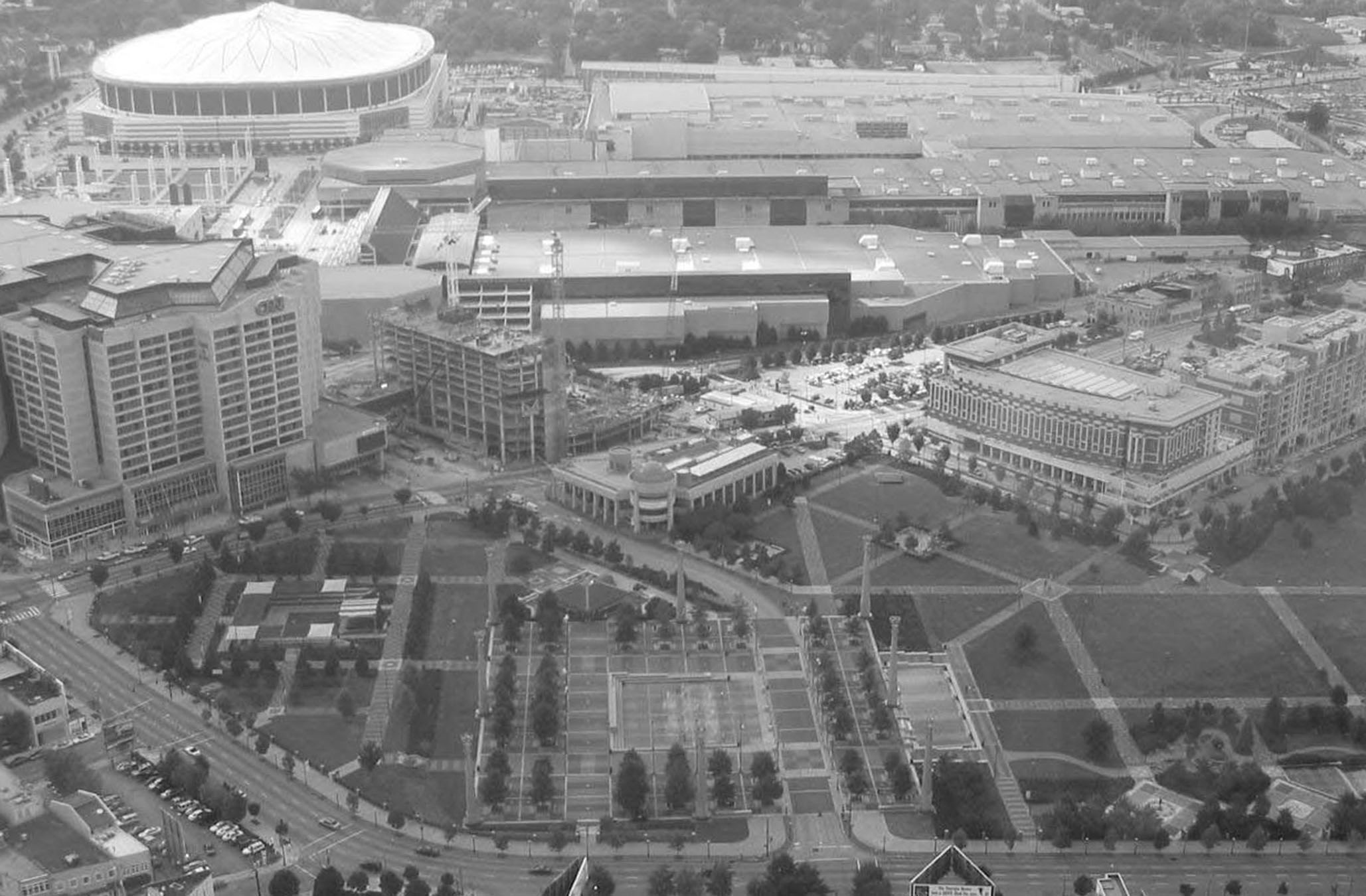
Volume 23, Issue 2: "Downtown Atlanta's Centennial Olympic Park"
Photo Courtesy of Truman Hartshorn, Georgia State University
Centennial Olympic Park, Atlanta, Georgia. Downtown Atlanta, long criticized for the lack of open civic space, added the Centennial Olympic Park in conjunction with the 1996 Summer Games. The Park has stimulated new mixed use development including sports, entertainment, hotel, and residential projects as well as loft housing redevelopment but little retail investment to date. Shown here in the view to the West from atop the 73 story Westin Peachtree Plaza Hotel on Peachtree Street, the Park is framed by the CNN Center, Phillips Arena, and the Georgia Dome to the left. In the center position one sees the Chamber of Commence (two-story building with dome), the expanding Omni Hotel (construction crane), and the World Congress Center, one of the largest convention centers in the country. At center right is the mid-rise Embassy Suites Hotel and new residential condominium complex. Not shown here to the right (north end of Park), lies the site for the proposed Aquarium complex recently funded by the retired Home Depot CEO, and the relocated Coca Cola Museum. Other residential towers are also being constructed near the Park and the former Baptist Tabernacle is now a live entertainment venue. —Truman Hartshorn, Georgia State Unversity, Atlanta, Georgia 
Volume 23, Issue 3: "Manhattan"
Photo ©2001-2002 www.arttoday.com

Volume 23, Issue 4: "Sydney Opera House"
Photo ©2001-2002 www.arttoday.com

Volume 23, Issue 5: "Chicago Transit Authority 'L' Station"
Photo Courtesy of Deborah Martin, University of Georgia
Chicago, Illinois. The view is from the Chicago Avenue Elevated station of the "Brown" and "Purple" lines,
looking southeast toward downtown. The station is directly above the north-south Franklin Avenue, at east-west Chicago
Avenue. Formerly mostly warehouses, and more recently an artists' loft district, this area is experiencing condo-style development.
New shops and restaurants have also opened in the area, aimed at a young, upwardly mobile population. It is within
walking distance of Cabrini Green, formerly public housing that has partially been razed for new townhomes and apartments
aimed at middle- and upper-income residents.
—Deborah G. Martin, University of Georgia, Athens, Georgia 
Volume 23, Issue 6: "Amsterdam Centraal Station"
Photo ©2001-2002 www.arttoday.com
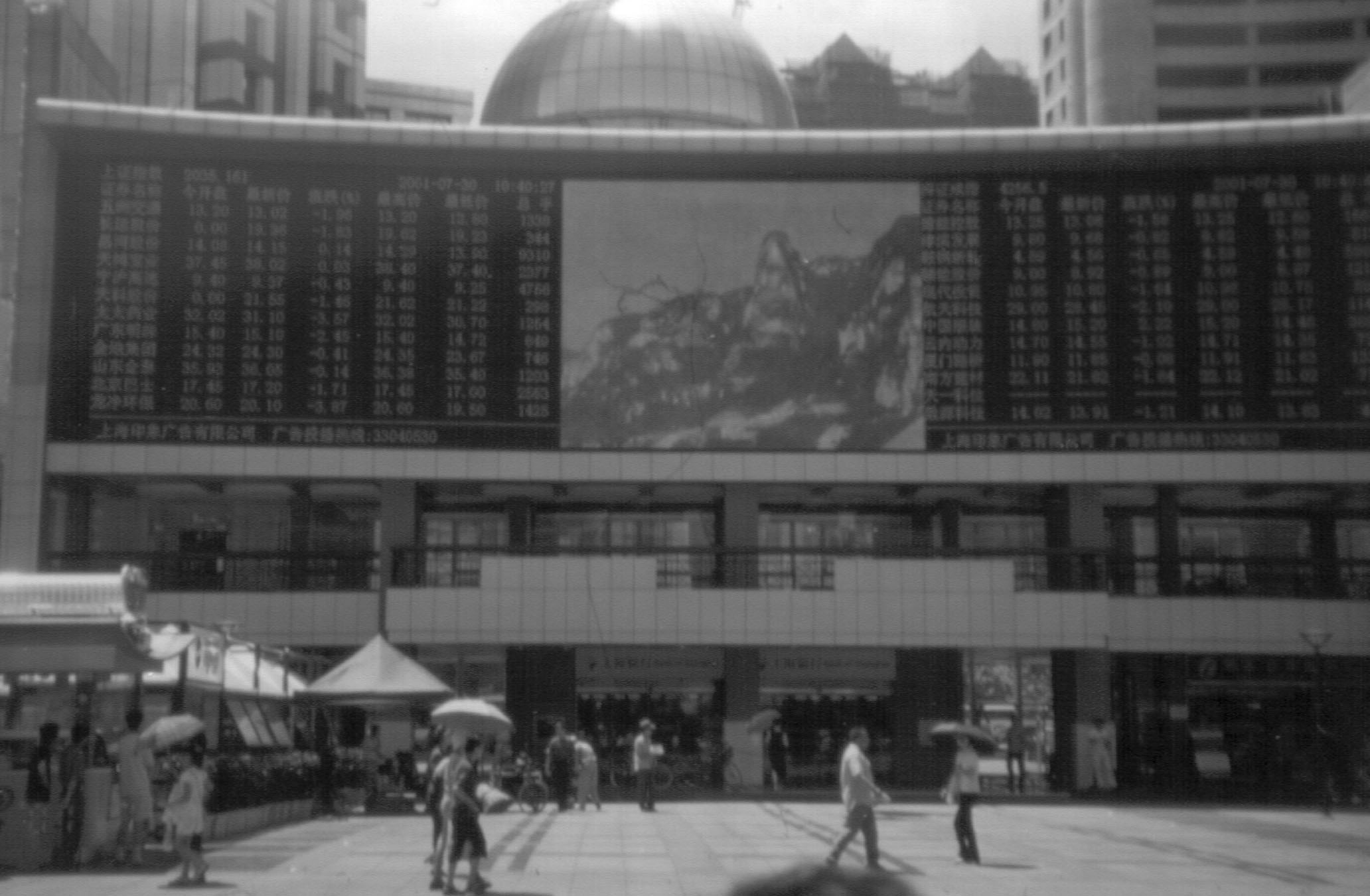
Volume 23, Issue 7: "Shanghai Stock Market Prices Listing on Nanjing Road, Shanghai"
Photo courtesy of Richard Grant, University of Miami

Volume 23, Issue 8: "Italy's Duomo di Milano"
Photo ©2001-2002 www.arttoday.com
Back to the Top
|
|